Stars For All Seasons Part 4

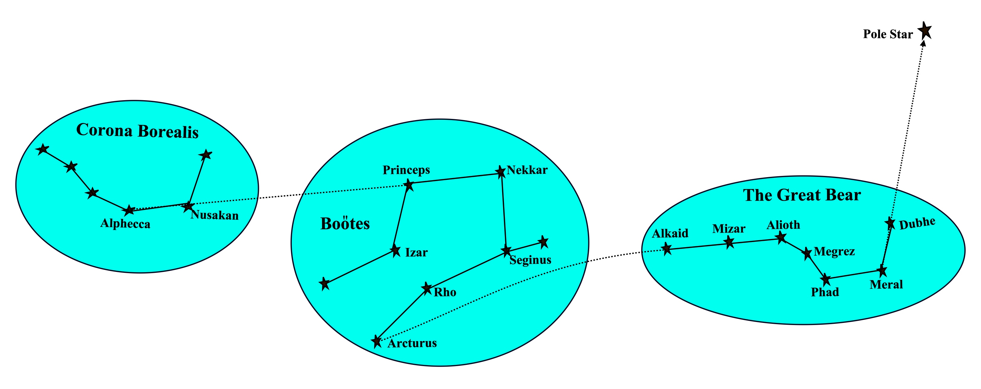
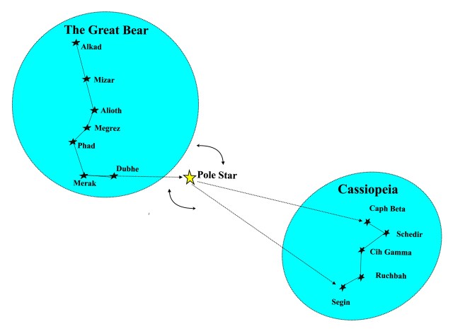
Circumpolar Stars In The Southern Hemisphere.

In the previous article of this series, we discussed circumpolar stars of the Northern Hemisphere and  in this article we will look at some of the circumpolar constellations in the Southern Hemisphere.

Centaurus is the ninth largest of all constellations and extends from about 30o south to 61o south.  It is one of the brightest constellations in the sky and contains three navigation stars: Hadar, Menkent and Rigil Kentaurus.  Hadar and Rigil Kentaurus are circumpolar in the Southern Hemisphere from about 31o south but Menkent, the most northern of the three, is circumpolar from  55o south.


Finding Centaurus.  If we take a line from Arcturus in the constellation Boötes to Spica in Virgo and extend that line by another 55o, it will point to the constellation Centaurus as shown in the diagram below:


Centaurus is associated with several mythological tales and is depicted as a centaur, half man and half horse.  In Ancient Greek mythology, the constellation is associated with Chiron, the centaur who mentored many of the Greek heroes including Theseus, Jason and Heracles.

 Crux, The Southern Cross  Crux is one of the best known constellations in the southern hemisphere, and is easily recognizable for the cross-shaped asterism named the ‘Southern Cross’. Crux (Latin for cross), it is one of the smallest constellations in the sky but also one of the brightest which makes it useful for astro navigation.

The cross has four main stars: alpha, beta, gamma and delta which mark the tips of the cross.

Alpha Crucis is also known as Acrux (a contraction of ‘alpha’ and ‘Crux’).  This is the brightest star in the constellation Crux; it is a navigational star and is circumpolar south of 28o south .

Beta Crucis, also known as Mimosa or Becrux, is the second brightest star in the constellation but is not a navigational star; it is circumpolar south of 40o south .

Gamma Crucis or Gacrux, is the third brightest star in Crux; it is a navigational star and is circumpolar below 32o south .

Delta Crucis or Palida is the fourth star and has variable levels of brightness making it unsuitable as a navigational star; like Beta Crucis, it is circumpolar south of  40o south.

Mythology.  Crux is associated with the mythology of several cultures.  Some Aboriginal cultures saw it the head of the ‘Emu in the sky’ while others saw it as representing the sky deity Mirrabooka and indeed that is the name that they gave to what we know as the ‘Southern Cross’.  In New Zealand, the Maori called the cross Te Punga (‘the anchor’) and in South America, the Incas called it Chakana (the stair).

Finding Crux.  The constellation Centaurus contains two bright stars which make excellent pointers to help us find the Southern Cross.  The Pointers as they are known, are Rigil Kentaurus and Hadar which are both navigational stars. The next diagram shows the relationship between the pointers and the Southern Cross.

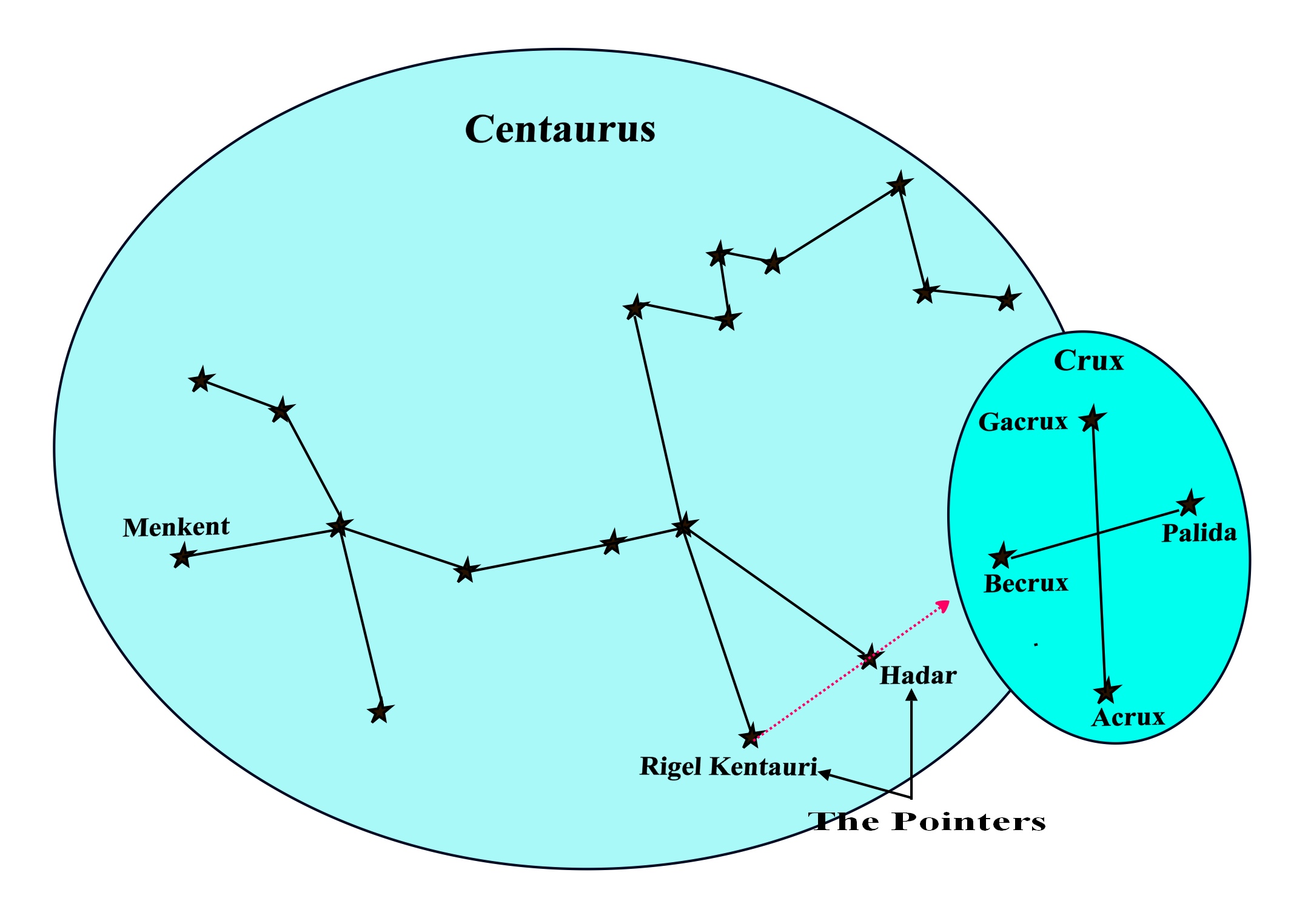
The constellation Centaurus appears to envelope Crux and indeed the ancient Greeks considered them to part and parcel of the same constellation.

 Carina

 Carina lies over the Southern Hemisphere and can be seen by observers located between 20°N and 90°S.  It is the 34th biggest constellation and it contains two navigation stars, Canopus and Miaplacidus.  Canopus is circumpolar below 38°S; it is second brightest star in the night sky and can be seen to the south of Sirius, the brightest star which lies in Canis Major.  Miaplacidus is circumpolar below 21°S; it is the second brightest star in Carina but only the 29th. brightest in the night sky.  Foramen (scientific name Eta Carinae) is circumpolar south of 30°S.  It is a variable star and was once the brightest star in the sky but currently its apparent magnitude is around 4.5.

Carina was once part of a larger constellation, Argo Navis which represented the ship on which Jason and the Argonauts sailed to find the Golden Fleece.  In that constellation, Carina represented the hull of the ship and the star Canopus marked the blade on one of the ship’s steering oars.

In 1763, Argo Nevis was divided into three smaller constellations: Carina, (the hull), Puppis (the stern) and Vela (the sails).

Vela. Vela represents the sails of the Argo Navis.  Its brightest star, Suhail has an apparent magnitude of 1.7 and is a navigation star;  it is circumpolar below 43°S


The star Markab, (declination 55°S) should not be confused with the star Markab that lays in the constellation Pegasus (15°N).  Vela’s Markab is not considered to be a navigation star even though it is slightly brighter than the Markab of Pegasus which is a navigation star. With a declination of 55°S Vela’s Markab is circumpolar below 36°S.

Koo She, which is Chinese for ‘bow and arrows’, is the second brightest star in the constellation but is not considered to be a navigation star even though it has a magnitude of 1.96.  The declination of Koo She is 54°S and it is therefore circumpolar from 36°S.

Puppis.

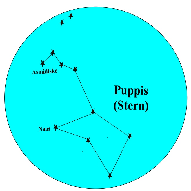
Puppis was said to be the stern of the Argo Navis but was sometimes known as the ‘poop deck’.  It has only two named stars and neither of these are classified as navigation stars.

The star Naos has a declination of 40°S and is therefore circumpolar below  51°S.

The star Asmisdiske with a declination of 25°S will be circumpolar below 66°S.

The diagram below shows how the three new constellations once fitted together to form the ship Argo Navis and if we continue to think of them in that way, we will have a ready-made aid to  locating them in the night sky.

Triangulum Australe (The Southern Triangle).This is a small constellation located over the southern hemisphere. Its name is Latin for “the southern triangle”, which distinguishes it from Triangulum, the Summer Triangle, in the northern sky.   Its name is derived from its three brightest stars Atria, Betria and Gatria which form an almost equilateral triangle and are sometimes called the ‘Three Patriarchs’.   Atria is the brightest of the three and the only navigation star in the constellation.  Atria and Gatria are circumpolar at latitudes greater than 21°S while Betria, the northernmost of the three, is circumpolar below  28°S.

Finding Triangulum Australe.  As shown earlier in this article, the stars Rigel Kentauri and Hadar in the constellation Centaurus can be used as  pointers to the star Becrux in the Southern Cross (Crux).  If we line the pointers up in the opposite direction, that is pointing from Hadar to Regel Kentauri and extend that imaginary line by about 15 to 20 degrees it will point to Betria in Triangulum Australe.  The diagram below demonstrates this.

Pavo.  This is the last constellation that we will visit in this article although there are many more that we could discuss.

If we draw an imaginary line between the stars Gatria and Atria in Triangulum Australae and extend that line westwards by about 20° it will point to the star Peacock, the brightest star in the constellation Pavo.  Peacock, is a navigation star and is circumpolar below 34°S as are all the stars in Pavo.

pavo update


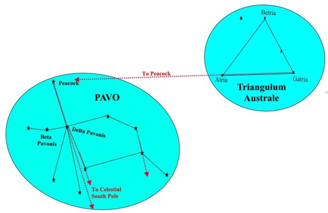
Some of the stars in Pavo form an asterism called “the Saucepan”, which has been used as a navigational tool to point toward the southern celestial pole; however, because most of the stars in the saucepan are very faint, it is difficult to pick it out with the naked eye.   Another method is to imagine a line from the star Peacock to the star Delta Pavonis, the third brightest star in Pavo, and as shown in the diagram above, this line will also point to the Celestial South Pole.

Links:  Stars For All Seasons – Part 1

Stars For All Seasons – Part 2

Stars For All Seasons – Part 3

Books of the Astro Navigation Demystified Series:

Astro Navigation Demystified.

Applying Mathematics to Astro Navigation

Astronomy for Astro Navigation

Celestial Navigation.  Theory and Practice

email: astrodemystified@outlook.com

Posted in astro navigation, Astro Navigation Demystified, astronomy, celestial navigation, navigation | Tagged , , , | Leave a comment

Stars For All Seasons – Part 3

Circumpolar Stars

“Know The Stars And You Will Always Have A Compass”.    (Michael Punk. 2002. The Revenant).

In article one of this series this article, we briefly touched on the topic of circumpolar stars and here we continue with that discussion.

A circumpolar star is one that, from a given latitude on Earth, never rises or sets because it is always above the horizon.  Whether or not a star is circumpolar depends on two things, the star’s declination and the observer’s latitude.  If the angular distance of a star from the nearest pole is less than the latitude of the observer, then that star will be circumpolar to the observer.  (The angular distance of a star is the complement of its declination so if its declination is S57o then its angular distance from the South Pole will be 33o).  For example, if an observer’s latitude is 51oN and a star’s declination is N66o then the angular distance of the star will be 24o which is less than the latitude and so it will be circumpolar to the observer.

Circumpolar Constellations In The Northern Hemisphere:

Ursa Major.  The best known and easily recognisable constellation in the northern hemisphere is the constellation Ursa Major which is also known by various names such as the Great Bear, the Big Dipper and the Plough.

Ursa Major contains 3 navigational stars named Dubhe, Alioth and Alkaid and is circumpolar from about 42o North (the angular distance of Alkaid is 41o).

Ursa Minor. The Little Bear (also known as the Little Dipper).    Ursa Minor contains the star Polaris which has a declination of 89°16’N. almost coinciding with the Celestial North Pole and for this reason it is also known by various names including Pole Star, North Star, Lodestar and the Guiding Star.  Polaris is only the 45th brightest star in the sky; however, it has always played an important role in navigation; not only because it indicates the direction of north but also because it is useful for position fixing in the north polar-regions.  Polaris is circumpolar in the Northern Hemisphere from just above the Equator while Kochab, the southernmost star in Ursa Minor which has a declination of N74° is circumpolar from latitudes north of 16°N.

Finding the Pole Star.  Ursa Major contains a reference line known as the line of pointers.  The line joining Merak to Dubhe, when extended will point to Polaris in the constellation Ursa Minor as illustrated in the following diagram.

Ursa Major and Ursa Minor are associated with several mythological stories.  In one such story, the two nymphs who had nursed Zeus as an infant were sent into the sky by him to form constellations.  The nymph Adrasteia became the constellation Ursa Major while the other, Ida became Ursa Minor.

Cassiopeia.  We briefly discussed Cassiopeia in article one; it is quite an easy constellation to find because of its ‘W’ shape which sometimes appears to be hanging upside-down as it revolves around the Pole Star. The brightest star in Cassiopeia is Alpha Cassiopeia otherwise known as Schedir which is a navigational star and is circumpolar above 32°North.

How to find Cassiopeia.  Cassiopeia can be located along a line of reference from the Pole Star at an angle of 135o to the line of pointers in Ursa Major, as the diagram below shows.   As Ursa Major revolves around the Pole Star, so do the five stars of Cassiopeia but Segin always keeps its position 135o from the line of pointers. The angular distance of star Segin from the Pole Star is 30o or roughly one and a half hand-spans.

The constellation Cassiopeia is associated with Queen Cassiopeia in Greek mythology.  In punishment for her vanity, she was made to sacrifice her daughter Andromeda and as further punishment, she was sent into the sky to circle the North Pole forever.

Perseus.  If a line is drawn from Navi to Ruchbah in Cassiopeia, it will point almost directly towards the star Mirfak of the constellation Perseus at about one hand-span as shown in the diagram below.

Even though Perseus’s stars are bright relative to other constellations, Mirfak which is circumpolar in the Northern Hemisphere above 41oN, is its only navigational star,

This constellation is associated with the Greek mythological hero Perseus who, on the orders of King Polydectes, slayed the Gorgon Medusa who had the power to turn people to stone.  Polydectes had hoped that Perseus would not return and when he did, he became hostile.  Perseus was so angered by this that he took out the head of Medusa and turned Polydectes to stone.  The wife of Perseus was called Andromeda and the constellation that represents her lies side by side with the one that represents him.

Taurus, The Bull.  Taurus is a constellation in the northern hemisphere and is visible at latitudes from 90oN to 65oS; for navigators, it is best seen during nautical twilight in January.

Aldebaran, which is known as Taurus’ Eye, is the 14th brightest star in the sky and is an important navigational star.  The star at the tip of the northern horn of Taurus, Al Nath (sometimes spelled El Nath) is the second brightest star in the constellation and is also a navigational star.  In earlier times this star was considered to be shared with the constellation Auriga, forming the right foot of the Charioteer as well as the Northern horn of the bull.  Al Nath is circumpolar from 60oN.

Finding Taurus.  If we imagine a line from Phad to Meral in Ursa Major and extend it for a distance of 80o or roughly 4 hand-spans it will point directly to the star Aldebaran in the constellation Taurus. Once we have located Aldebaran the remaining stars of Taurus can easily be identified.

Taurus is associated with several mythological beliefs.  In Greek mythology, Zeus was said to have disguised himself as a bull to abduct Europa, the daughter of king Agenor.  The ancient Egyptians believed that the constellation represented the sacred bull associated with spring and Babylonian astronomers called it the ‘Heavenly Bull’.

Auriga, The Charioteer. In mythology, Auriga is associated with Myrtilus the charioteer because the shape of the constellation was said to resemble a pointed helmet of a charioteer.  It is also identified with Hephaestus, the god of the blacksmiths who invented the chariot.Capella is the brightest star in the constellation Auriga and the 6th brightest in the northern hemisphere. It is circumpolar at latitudes above 45oNorth.

The diagram below shows the star Al Nath (sometimes spelled El Nath) forming the right foot of the Charioteer and as has already been explained, it was once considered to be shared with the constellation Taurus where it forms the northern horn of the bull.  When the constellation boundaries were changed in 1930, Al Nath was assigned solely to Taurus.  However, if we still think of Al Nath as the foot of Auriga as well as the northern horn of Taurus, we will have an easy method of finding both Auriga and Taurus as we can see from the diagram below.

Watch out for part 4 of this series in which Southern Hemisphere circumpolar stars are discussed.

Links:  Stars For All Seasons – Part 1

Stars For All Seasons – Part 2

Books of the Astro Navigation Demystified Series:

Astro Navigation Demystified.

Applying Mathematics to Astro Navigation

Astronomy for Astro Navigation

Celestial Navigation.  Theory and Practice

email: astrodemystified@outlook.com

Posted in astro navigation, Astro Navigation Demystified, astronomy, celestial navigation | Tagged , , | Leave a comment

Stars For All Seasons – Part 2

Summer Stars in the Northern Hemisphere 

Winter Stars in the Southern Hemisphere

“Know The Stars And You Will Always Have A Compass”.    (Michael Punk. 2002. The Revenant)

In the last article, we discussed Rotation (the reason the stars seem to rise earlier each night) and Revolution (the reason the stars that we see in the night sky change from season to season). In this article, we look at some of the stars that we see in the Northern Hemisphere’s summer night sky.

 The easiest way to locate the stars in which we are interested is to locate the constellations to which they belong.  One method of doing this is to establish reference lines in known constellations and from these, memorise the directions in which other constellations lie.

The Summer Triangle.  The stars Deneb in the constellation Cygnus, Altair in Aquilla and Vega in Lyra form an astronomical asterism known as the ‘Summer Triangle’ which can be seen during summer and autumn in the Northern Hemisphere. The diagram below shows how the triangle is formed by imaginary lines drawn between those stars.

 summer triangle


Lyra The Harp  Lyra is a constellation in the Northern Hemisphere and is visible between latitudes 90oN and 40oS.  From a navigator’s point of view, it is best seen during nautical twilight in the late summer and autumn.  Lyra contains Vega, which is the second brightest star in the northern hemisphere and is a navigational star.

In Greek Mythology, when Orpheus died, he dropped his lyre into a river from where it was retrieved by an eagle sent by Zeus.  Zeus then sent both the lyre and the eagle into the sky as the constellations Lyra and Aquila.

 Aquila, The Eagle   Aquila is visible between latitudes 85oN and 75oS and is also best seen during nautical twilight during the late summer and autumn.  Aquila contains Altair, the 12th brightest star in the sky and also a navigational star.

In Greek mythology, Aquila, the eagle, carried thunderbolts for Zeus and as explained above, later rescued the lyre of Orpheus from the river.

 Cygnus The Swan (The Northern Cross)  The constellation Cygnus contains 6 stars, the brightest of which is Deneb, the 19th brightest star in the sky and a navigational star. As with Lyra, Cygnus is visible between latitudes 90oN and 40oS.  For navigators it is best seen during nautical twilight in late summer and autumn.  Cygnus contains an asterism formed by the brightest stars in the constellation which is named the Northern Cross.

In Greek mythology, Orpheus was said to have been turned into a swan by Zeus and sent into the sky as the constellation Cygnus along with Aquila and Lyra.

Finding the Summer Triangle.  In the diagram below, if we join the star Meral in the constellation Great Bear (Ursa Major) to a point midway between the stars Alioth and Dubhe also in the Great Bear and then extend this line, it will point to Vega, the brightest star in the constellation Lyra.  In this way, The Great Bear gives us a sign post to the Summer Triangle.

triangle

Boötes and Corona Borealis.  If we take a line from Alioth to Alkaid in the Great Bear and extend that line in an imaginary curve for about roughly three hand-spans as shown in the diagram below, it will point to Arcturus, the brightest star in the constellation Boötes.

bootes-and-corona.jpg

Boötes  The Herdsman. Boötes is the 13th largest constellation in the night sky; it is located in the northern hemisphere and can be seen from 90oN to 50oS. The ancient Greeks visualised it as a herdsman chasing Ursa Major round the North Pole and its name is derived from the Greek for “Herdsman”.

Boötes contains Arcturus, the fourth brightest star in the sky and  a navigational star.  The ancient Greeks named Arcturus the “Bear Watcher” because it seems to be looking at the Great Bear (Ursa Major).

Corona Borealis The Northern Crown.  If we next take a line from Nekkar to Princepes in Boötes, and extend that line by about one and a half hand-spans, it will point to Nusakan in the close by Corona Borealis constellation.   Corona Borealis, whose name in Latin means ‘northern crown’, is a small constellation in the northern hemisphere and can be seen between latitudes 90oN and 50oS.

The main stars in Corona Borealis form a semi-circle which is associated with the crown of Ariadne in Greek mythology.  It is said that the crown was given by Dionysus to Ariadne on their wedding day and after the wedding, he threw it into the sky where the jewels became stars which were formed into a constellation in the shape of a crown.  Alphecca, the brightest star in the group, is a navigational star and is best seen during nautical twilight in July.

Sagittarius, The Archer.  Sagittarius is a large constellation lying over the southern hemisphere and is visible between latitudes 55oN. and 90oS. It contains several bright stars including two navigational stars, Nunki and Kaus Australis which are best seen during nautical twilight in August.

In ancient Greek mythology, Sagittarius was said to represent the Archer, a beast called a Centaur which was half man and half horse.  In the representation below, the Archer has a drawn bow with the arrow pointing to the star Antares, the heart of the scorpion, which had been sent to kill Orion.


Finding Sagittarius.  The Summer Triangle provides a useful pointer to Sagittarius.  If we draw an imaginary line from the star Deneb through the star Altair in the Summer Triangle and extend that line by about 20o or one hand-span, it will point to the constellation Sagittarius as the diagram below shows.

 Note. Nowadays, the Sun is over the constellation Sagittarius at the Winter Solstice on 21/22 December when the Sun’s declination reaches its southernmost latitude of 23.4o south. However, in ancient Greek times, the Sun passed through the constellation Capricornus at this time hence the reason for naming the latitude 23.4o south the Tropic of Capricorn.

 Scorpius (Scorpio), The Scorpion.  The constellation Scorpius lies above the southern hemisphere and is visible between latitudes 40oN and 90oS.

Scorpius has several bright stars which, between them, form the shape of a scorpion.  The brightest star in Scorpius is Antares which is often mistaken for Mars because of its reddish orange colour.  Antares is the 16th brightest star in the sky and is a navigational star.  The second brightest star in Scorpius is Shaula which is said to represent the sting in the tail of the scorpion.  Shaula is also a navigational star. For navigation purposes, Antares and Shaula are best seen during nautical twilight in July.  In Greek mythology, Scorpius represents the scorpion that the goddess Artemis sent to sting and kill Orion who had tried to ravish her.

The legend that the Archer’s arrow in Sagittarius points to Antares helps us to find and identify Scorpius. The line from Nunki to Kaus Media represents the arrow, the head of which points to Antares in Scorpio.  It also helps to remember that the orange star Kaus Media points along the line of the arrow towards the red star Antares. The bright red glow of Antares further helps us to identify Scorpius.

The angular distance from Kaus Australis in Sagittarius to Shaula in Scorpius is approximately 10o or roughly equivalent to the width of the palm of the hand when held at arms length.

Watch out for part 3 of this series in which ‘circumpolar stars’ are discussed (we briefly touched on these in part 1).

Link:  Stars For All Seasons – Part 1

Reference for the quote “Know the stars and you will always have a compass”: Michael Punk. 2002. The Revenant

Books of the Astro Navigation Demystified Series:

Astro Navigation Demystified.

Applying Mathematics to Astro Navigation

Astronomy for Astro Navigation

Celestial Navigation.  Theory and Practice

email: astrodemystified@outlook.com

Posted in astro navigation, Astro Navigation Demystified, Astro Navigation Topics, astronomy, celestial navigation | Tagged , , , | Leave a comment

Stars For All Seasons Part 1

Often asked questions:

Why do the stars seem to rise earlier each night?

 Why do the stars that we see in the night sky change from season to season?

 There are two separate reasons for these phenomena, Rotation and Revolution.

I.e. The Earth rotates about its axis while it revolves around the Sun.

Rotation.

The Earth rotates from west to east about its axis of rotation which is a line joining the celestial poles and if this axis is produced far enough, it will cut the celestial sphere at a point marked by the North Star (Polaris) as shown in the diagram.  Facing north from the Earth, the Pole Star appears stationary, and the other stars appear to rotate from east to west around the Pole Star although in fact the positions of the stars are fixed and it is the Earth which is rotating from west to east.


The time taken for a star to complete a circuit around the Pole Star is called a star’s day or sidereal day.  If the sidereal day were to be exactly 24 hours, as is the Mean Solar Day, then the stars would rise and set at the same times every day.  However, the Earth completes each rotation about its axis in 23 hours, 56 minutes and 4 seconds so the stars will take the same amount of time to circuit the Pole Star and that is the length of the sidereal day. Therefore, if a star rises in the east at a certain time on a certain day, it will next do so  23 hours, 56 minutes and 4 seconds later. In other words, the star in question will rise 3 minutes and 56 seconds earlier each day (usually rounded off to 4 minutes).

For example, Say that Arcturus (the brightest star in the northern celestial hemisphere) rises at 18.00 mean time on a certain day; we know that it will rise again 23 hrs. and 56 mins. later so we can easily calculate that it will rise at 17.56 mean time the next day (4 minutes earlier).

Revolution.  In the diagram below we see the Earth as it orbits the Sun or to put it another way, we see it as it revolves around the Sun.  The positions of some of the more well known stars in relation to our Sun are also shown and it can be seen that, as the Earth follows its orbital path, different stars will gradually come into and out of view in the night sky.  For example, we will see Sirius in the night sky during the Northern Hemisphere’s winter but we won’t see it during the summer nights.  Its not that it’s in a different place, its just that it is now on our daylight side.

So, in the Northern Hemisphere, we have our winter stars such as Aldebaran, Rigel and Betelgeuse and we have our summer stars such as Nunki and Kaus Australis; of course, it is the other way round for the Southern Hemisphere.

Circumpolar Stars.  Depending on the latitude of the observer, some stars will never rise or set because they will always be above the horizon, these are known as circumpolar stars.

Example.  The diagram below shows the constellations Ursa Major (Great Bear) and Cassiopeia which are both circumpolar to observers throughout the Northern Hemisphere and down to 20o South in the Southern Hemisphere.   As Ursa Major revolves about the Pole Star so do the five stars of Cassiopeia.

bear to cassiopeia update

There are many other circumpolar constellations such as Ursa Minor, Auriga and Perseus in the Northern Hemisphere and Centaurus and Crux in the Southern Hemisphere; we will be looking at these more closely in future articles of this series.


In the next article of this series, we will discuss the stars that we can see in the Northern Hemisphere’s summer sky.

Books of the Astro Navigation Demystified Series:

Astro Navigation Demystified.

Applying Mathematics to Astro Navigation

Astronomy for Astro Navigation

Celestial Navigation.  Theory and Practice

email: astrodemystified@outlook.com

Posted in astro navigation, Astro Navigation Demystified, astronomy, celestial navigation | Tagged , , | Leave a comment

Accuracy of Sight Reduction Methods.

In my recent article ‘Why Astro‘, I highlighted the risks in using the GPS.  Since writing that article, I am frequently asked “if astro / celestial navigation is to be used, which of the many systems is the best”.  Sight reduction methods tend to fall under two categories, Formula and Tabular. (Computerised  sight reduction systems will involve a combination of these methods i.e. mathematical calculation of data contained within a matrix held in a database).  Therefore, in this article, I will discuss the relative merits of these two methods.

Please note that the terms ‘Astro Navigation’ and ‘Celestial Navigation’ are synonymous but for the rest of this article I will use the term astro navigation.

 Sight Reduction. This is the process of reducing the data gathered from observations of celestial bodies down to the information needed to establish an astronomical position line.  The two essential items of data that we need to begin the process of sight reduction are the azimuth and the altitude of the celestial body in question.

The azimuth gives us the direction of the celestial body from the calculated position.

When we measure the altitude, what we are really trying to establish is the zenith distance (Zenith Distance = 90o – Altitude) that is the distance to the geographical position of the body.  We measure the altitude at our true position and we calculate the altitude at the DR position (or assumed position); this enables us to calculate the zenith distances at the two positions.  The difference between the two zenith distances will give us the distance from the DR position to the true position measured along the direction line of the calculated azimuth.

Measuring the altitude and azimuth at the true position with a sextant and azimuth compass is relatively straightforward but calculating what they would have been at the DR or Assumed position is the real work of sight reduction.

Formula Methods. The traditional way of calculating the azimuth and zenith distance at the DR position is by spherical trigonometry. Before the advent of the electronic calculator, this would have been a very lengthy and time consuming method involving the use of tables of logarithms to make calculations involving the Haversine Formula.  However, these days we can still make use of spherical trigonometry with the use of a scientific calculator and with the application of just two formulas derived from the Cosine Rule, one for the azimuth and one for the zenith distance.  With just a little practice, it will be found that this method is quick and easy to apply.  We usually refer to these methods as Formula Methods.  Accuracy is the greatest advantage of formula methods; calculations are usually made to 3 or 4 decimal places but this can be extended if greater accuracy is required.   Of course there is always the risk of human error when making mathematical calculations but with an electronic calculator, it takes very little time to double check.

TABULAR METHODS.  During the twentieth century, tabular sight reduction methods were first devised and today there is such a proliferation of these methods that choosing one can be very confusing.  Tabular methods do not require a knowledge of spherical trigonometry; they involve the use of sets of pre-computed tables of data from which the altitude and azimuth can be interpolated.  The disadvantage of these tables is that they have to be entered with the latitude and Local Hour Angle rounded to the nearest degree so that calculation of the altitude and azimuth depends on interpolation and extrapolation.  To achieve this, an ‘Assumed Position’ has to be chosen.  This is a position where the latitude and longitude closest to the DR position have the following properties: The assumed latitude is the DR latitude rounded up to the nearest whole degree and the assumed longitude is the longitude closest to the DR longitude that makes the local hour angle a whole degree. In comparison, when we solve the problem directly by spherical trigonometry, we use the latitude and longitude of the DR or EP position and we make exact calculations without the inaccuracies of interpolation methods.  Of course the greatest advantage of tabular methods is that the navigator does not require a knowledge of trigonometry and the only mathematical calculations needed involve simple arithmetic.

Comparison.  Below, we compare the accuracy of calculations made to establish astronomical position lines using two different methods, one a formula method and the other a tabular method. We use identical input data for both examples.  The first example shows the calculations made using the cosine formula method and the second shows those made using the Rapid Sight Reduction Method (NP303).  Please note that the sight reduction forms used in these examples are not standard but are designed as learning aids for use with exercises in my books.

Cosine Formula Sight Reduction Method

Rapid Sight Reduction Method

Findings.  There is a difference of 1.558 nautical miles in the calculation of the intercepts produced by the two methods, that is to say there is a difference of 1.558 arcminutes in the two sets of calculations.  In terms of distance, 1.558 nautical miles seems quite a lot but in terms of mathematical calculation, 1.558 arcminutes does not seem so great a difference (unless you are a rocket scientist of course).  So how do we decide which method is the more accurate?

  • On the one hand, it could be argued that the formula method is the more accurate of the two methods for the following reasons: There are accumulative and unavoidable errors caused by the addition and rounding-off of quantities taken from sight reduction tables whereas with formula methods; calculations are usually made to three or more decimal places thereby providing a greater degree of accuracy.
  • On the other hand, it could be argued that sight reduction by the use of spherical trigonometry is time consuming and gives considerable scope for mathematical error. Because time and accuracy are of the essence in practical navigation, it is an advantage to be able to calculate altitude and azimuth by relatively simple table operations.

Summary.  The arguments above are really inconclusive and it would seem that, from the point of view of accuracy, there is not a great deal of difference between the two methods.  Yet, we are told that the accuracy of astronavigation position fixing is only plus or minus 1 nautical mile, so if it’s not the method, where does this level of inaccuracy stem from?

Errors That Occur No Matter Which Sight Reduction Method Is Used.  If we are concerned about accuracy in astro navigation, it matters not which sight reduction method we use, the real danger of inaccuracy lies in other areas.   Inaccuracy in calculations may be introduced by a number of contributory errors irrespective of the sight reduction method being used; these errors are summarized below.

Errors in the observed altitude.   Even when the sextant altitude has been corrected for index error, semi-diameter and parallax, the resultant altitude reading may still be incorrect owing to a combination of other errors such as incorrect calculated values for dip and refraction.  An error in the observed altitude will lead to an error in the observed zenith distance.

Refraction.  A pronounced error in refraction is likely to occur when the altitude is below 15o.  The dip being affected by refraction is the most likely cause of error; when atmospheric conditions are abnormal, the actual value of dip may differ from the tabulated value by up to 10′.

Deck-watch error.  If the deck-watch error is incorrect, the GMT and the LHA will be incorrect.  An error in the LHA will lead to an error in the calculated altitude and this will cause the position line to be displaced.

Errors in the D.R. position.  Errors in the course and distance laid down on the chart may result from a combination of inaccurate plotting, compass error. the effects of wind and tidal stream and incorrect calculation of speed made good over the ground.  An error in the DR position and resultant assumed position will lead to errors in the estimated longitude and hence the local hour angle and this in turn will lead to an error in the calculated altitude.

Nautical Almanac.  There are accumulative and unavoidable errors caused by the addition and rounding-off of quantities taken from the almanac.

Errors In Observed Positions Derived From More Than One Position Line.  Position lines obtained from two or more astronomical observations are not likely to pass through a common point.  The reasons for this are firstly, the observations are not likely to be taken simultaneously since it is not possible to take sextant readings of three several celestial bodies at the same instant.  The faster a vessel travels, the greater the movement of the observer between the three observations and the more significant this error becomes even when special methods of calculation such as ‘MOO’ are used.  Secondly, observed altitudes are very seldom correct and therefore, the resultant observed zenith distances will not be correct.  For these reasons, the resultant position lines will be displaced and a ‘cocked-hat’ will be formed and because the position within the triangle of the cocked-hat is arrived at by guess-work, it is unlikely to be correct.

Conclusion:  Arguments concerning the relative accuracy of different sight reduction methods are not important, the real cause of inaccuracy in astro navigation is more likely to stem from the types of error described  above and these can occur irrespective of the method being used.  For the average yachtsman sailing in the vast expanse of the ocean, an accuracy level of plus or minus 1 nautical mile is probably nothing to worry about but for those engaged in activities that require a greater level of accuracy such as surveying and naval operations, it is obviously a matter of concern.

Wish to learn more?  The cosine formula method, it is comprehensively taught in my book ‘Celestial Navigation – Theory and Practice’.  The Rapid Sight Reduction Method is comprehensively taught in my book ‘Astro Navigation Demystified’.

Other Books by Jack Case:

Applying Mathematics to Astro Navigation

Astronomy for Astro Navigation

email: astrodemystified@outlook.com
Posted in astro navigation, celestial navigation, global positioning system, gps, Marine Navigation, mathematics, navigation, spherical trigonometry, trigonometry | Tagged , , , , | Leave a comment

In Defence of Mer Pas

The noon sight for latitude is a method of calculating latitude from the altitude of the sun at the instant it crosses your meridian and for this reason, the method is also known as ‘Meridian Passage’ or ‘Mer. Pas’.  I am often asked “what’s the point of this when we already know our latitude”; my reply is “unless we are using GPS, we won’t know our exact latitude and if we are using GPS, why are we bothering with astro navigation anyway?  The whole point is that, as I have pointed out in previous posts, we can no longer depend of GPS for a variety of reasons so prudent navigators will keep up their skills in astro navigation.

When we calculate a position fix using astro navigation, our starting points are our DR position or our EP which are only approximate positions so how can we say that there is no point in taking a noon sight when we already know our latitude.  The fact is that we don’t know our exact latitude and the noon sight is a way of calculating just that.

Why stop at latitude?  In the past, before the advent of the chronometer, the noon sight would enable the navigator to only calculate latitude but of course we can now use it to calculate longitude as well.  At the instant the sun crosses our meridian, we will know the exact local mean time (LMT) from the time of Mer Pas as listed in the Nautical Almanac for the day and by combining this with the Greenwich Mean Time which we take from the deck watch at the same instant, we are able to calculate our longitude as the following example taken from my book ‘Celestial Navigation’ shows:

Step 8. Calculate time difference between LMT and GMT of Local Mer Pas.

(Latitude West: GMT Best.  Latitude East: GMT Least).

GMT at Local Mer Pas: 16h 08m 20.1s        (Subtract from LMT if DR East)
LMT Mer Pas: 12h 02m 00.0s      (Subtract from GMT if DR West)
Time Diff: 04h 06m 20.1s
 
Step 9. Calculate Longitude at Local Mer Pas.  (Convert time difference to Arc)
Time Difference =

04h 06m 20.1s

Multiply the hours by 15 and divide the minutes and seconds by 4. Convert decimals to units of arc.

degs      mins      secs

Convert hours: 4= 4 x 15  = 60o  60o        00’     00”
Convert minutes: 6m = 6 ÷ 4  = 1o.5     1o     30’     00”
Convert seconds: 20.1s = 20.1 ÷ 4 = 5m.025     0o        05′     01″.5
Total   61o        35′     01”.5
Calculated Longitude: 6135’ 01″.5 W

So the noon sight can give us a position fix in terms of both latitude and longitude.

In the summer months, in the middle latitudes, there can be up to 16 hours from morning nautical twilight to evening nautical twilight so that means that we can go up to 16 hours between star and planet sights.  However, a noon sight will give us an accurate fix between twilight times and the good news is that there is only one celestial body to shoot and no ‘cocked-hat’.

Of course, there is also the ‘Intercept Method’ or ‘Sun Run Sun’ which will give us another fix during daylight hours.  The whole point is that we never know when poor visibility will prevent us from taking morning and evening sights so the more tricks that we have up our sleeves the better.

If you wish to learn about the Meridian Passage method try this link:

To learn about the Intercept method, click here.

To read why we cannot rely on the GPS read this:

Click here to read about the optimum time for star and planet sights.

Books of the Astro Navigation Demystified Series:

Astro Navigation Demystified.

Applying Mathematics to Astro Navigation

Astronomy for Astro Navigation

Celestial Navigation.  The Ultimate Course

Posted in astro navigation, astronomy, celestial navigation, gps, navigation | Tagged , , , | Leave a comment

Celestial Navigation – Theory and Practice

I have received a number of messages asking why my book ‘Celestial Navigation – The Ultimate Course’ is not currently available.  The truth is that I have been spending the winter months revising and updating this book and it will shortly be available on Amazon with a new sub-title: ‘Celestial Navigation – Theory and Practice’.

Celestial_Navigation_Cover_for_Kindle

The traditional method of celestial navigation involving the use of spherical trigonometry to calculate a vessel’s position is comprehensively taught in this book.  At first sight, the term ‘spherical trigonometry’ might seem quite daunting but with the knowledge of just two formulas and with a little practice of the methods explained in this book, it will be found to be quick and easy to apply as well as very accurate. With this method, we make accurate calculations using data taken directly from a vessel’s DR position and so avoid the inaccuracies of sight reduction methods that involve interpolation from tables using data based on an ‘assumed position’.

Although the prime aim of this book is to teach the practical skills of celestial navigation, it is emphasised that without knowledge, skill is nothing; at the same time, it is recognised that students quickly lose interest if they are expected to plough through reams of theory before they can get down to the business of learning the skills.  With this in mind, my book has been uniquely designed to teach the important skills from the outset while ‘tying-in’ the relevant theory as progress is made.  There are numerous examples and self-test exercises which enhance the learning process and help to embed the knowledge and skills needed to practise the art of celestial navigation.

Although it is a large book (containing 410, letter size pages) it is thoroughly cross-referenced and its layout enables the reader to move from one section to another without having to read it from beginning to end.

With regard to the mathematical aspects of the subject, I have adopted a language style which allows the text to flow smoothly and makes for enjoyable reading which is a departure from the stilted, academic language of many text books.

Note.  The terms celestial navigation and astro navigation are generally regarded as synonymous.

Books of the Astro Navigation Demystified Series:

Astro Navigation Demystified.

Applying Mathematics to Astro Navigation

Astronomy for Astro Navigation

Celestial Navigation.  Theory and Practice

email: astrodemystified@outlook.com

Posted in astro navigation, astronomy, celestial navigation | Tagged , , | Leave a comment

Why Astro?

In a recent article the discussion centred on our over-reliance on GPS for navigation at sea and the need for back-up systems.  The conclusion drawn was that we already have a back-up system, one that has been tried and tested over hundreds of years and that is astro navigation or celestial navigation as it is also known.  Was this the correct conclusion though?  In this article, we set out to explore other alternatives to GPS and to examine the pros and cons of astro navigation.

(Note. The terms astro navigation and celestial navigation are synonymous but for simplicity’s sake, we shall stick to astro navigation for the rest of this article).

What are the risks to the GPS? 

Spoofing – misdirecting  GPS navigation receiver so that it thinks it is somewhere it isn’t.

Jamming – the intentional emission of radio frequency signals to interfere with the operation of GPS receivers by saturating them with noise or false information.

Hacking – breaking into GPS software to discover a receiver’s location or to corrupt it..

Malicious viruses causing GPS to malfunction.

Magnetic storms can put power grids out of action, blank out communications systems and the GPS.

Electro-magnetic interference – can disrupt radio signals causing distorted GPS readings.

Damage to aerials and equipment can leave a vessel without access to the GPS

What are the alternatives?

Sebastion Anthony suggests creating a ground-based system which would involve blanketing the Earth with hundreds or thousands of radio transmitters at an immense cost. Surely though, that would be a waste of money and time; any system that is based on radio signals would be susceptible to the risks of spoofing, jamming and hacking in the same way that the GPS is.

There has also been talk of re-commissioning some of the electronic navigation systems that were in use before the advent of the GPS such as Omega, CONSOL, DECCA, and LORAN but once again, we are back to the problem of re-introducing radio based systems that are susceptible to the same risks as GPS.

George H Kaplan of the US Naval Observatory talks of using the Stellar Reference Frame as an alternative to GPS but this system also relies on electro-magnetic signals to communicate with satellites and so it is susceptible to exactly the same risks as the GPS.

Kaplan also talks of employing inertial navigation systems which are used in guided missiles, spacecraft, submarines and other naval ships and aircraft; however, he points out that these are simply sophisticated dead-reckoning systems that need to be aligned to a reference point, usually provided by GPS.  So, we come back to the problem of reliance on GPS.  However, he does suggest that where radar plots and weapon control systems in naval ships and aircraft need some sort of electronic input of position, inertial navigation systems may fit the bill during short periods of GPS malfunction.  However, none of this matters much to ‘yachties’ and small merchant ships unless small and cheap versions of such equipment becomes available to them.

The Only Real Alternative  It seems that the only real alternative to GPS is Astro Navigation and that is probably why the US Navy has recently re-introduced it in its training programmes while the Royal Navy continues to keep it in the curriculum for specialist navigating officers.

Advantages of Astro Navigation:

  1. It has global coverage.
  2. Does not require expensive equipment.
  3. Does not require a ground based support infrastructure.
  4. Does not emit electro-magnetic signals that can be detected by an enemy.
  5. Cannot be jammed, spoofed or hacked..
  6. Is not susceptible to disruption by solar storms or other electro-magnetic disturbances.

Disadvantages of Astro Navigation:

  1. Can be hampered by cloud cover except in aircraft.
  2. Inherent Errors in data and calculations. U.S. Navy and Royal Navy navigators are taught that the accuracy of astro navigation is ±1 minute of arc or 1 nautical mile. For details of inherent errors in astro navigation click here.
  3. Even with a highly skilled navigator it can take several minutes to obtain a celestial fix whereas a GPS fix is more or less instantaneous.

Links:

  1. What’s the point of Astro Navigation when we have the GPS?
  2. Could the Global Positioning System fail?
  3. The accuracy of astro / celestial navigation.
  4. Royal Navy officers are still trained to navigate by the stars.
  5. Celestial Navigation: U.S. Navy resurrects ancient craft.
  6. Ships fooled by GPS spoofing attack.
  7. Our terrifying reliance on GPS.
  8. New technology for celestial navigation.

Books of the Astro Navigation Demystified Series:

Astro Navigation Demystified.

Applying Mathematics to Astro Navigation

Astronomy for Astro Navigation

Celestial Navigation.  The Ultimate Course

email: astrodemystified@outlook.com

Posted in astro navigation, celestial navigation, electronic navigation systems, global positioning system, gps, Marine Navigation, navigation | Tagged , , , | Leave a comment

Astro Navigation in the Forests of the Iroquois

Link: History of the Mason Dixon line

Jeremiah Dixon and Charles Mason plotted the famous Mason Dixon Line in 1765, long before the days of GPS or any other electronic navigation equipment. How was it then that they were they able to fix positions from the midst of the forests of the Iroquois?

They would not have been able to survey the land using triangulation methods because suitable landmarks would have been hidden by the trees.  They would not have been able to measure the altitude of celestial bodies because there would not have been a visible horizon.  All they would have been able to see would be a small circle of sky through the canopy above them and therein lies the clue.

They used an instrument known as a zenith sector which is a fixed vertical telescope through which an observer is able to view a small circle of sky centred at the zenith of his geographical position.  By using this device, they were able to accurately measure the zenith distance of celestial bodies that came within the telescope’s field of view.

In the diagram below, Z marks the zenith of the observer, X is the position of a celestial body and O is the Earth’s centre.  The zenith distance is the angular distance ZX which is subtended by the angle XOZ .  In other words it is the angular distance from the observer’s zenith to the celestial body.  (For a fuller explanation of zenith distance follow this link:)


By measuring the zenith distance of a celestial body at the instant that it crosses the observer’s meridian, the observer is able to determine the latitude of his position because the zenith distance will be equal to the distance from the latitude of the geographical position of the body to the latitude of the observer in nautical miles measured north or south (click here for an explanation of this).

Mason and Dixon plotted their line in this way choosing stars whose declinations were close to the latitude 39o 43′ N, the east/west boundary between Pennsylvania and Maryland.  Because the chronometer had not yet been invented, they were not able to calculate longitude which partly explains why their line ran along a parallel of latitude.

They chose to use only stars for their observations because the declination of a star changes very slowly and can be considered to be fixed for short periods of time.  Furthermore, the magnification of the zenith sector telescope is far greater than the telescope of a sextant and so they were able to use many faint stars that we would not normally be able to use for navigation.

To establish a north/south boundary they would have followed a line bearing true south or true north from a known landmark such as a hill or small town. It is interesting to note that the majority of the boundaries between American states, which were established before the advent of the chronometer, also ran east/west or north/south.

The boundary between Delaware and Pennsylvania, which was also fixed by Mason and Dixon, involved mainly conventional surveying techniques because it followed an arc known as the ‘twelve mile circle’ around the town of New Castle.  Similarly, the Delaware-Maryland boundary was based on conventional surveying because it was designed to bisect the Delmarva Peninsular instead of following a meridian.

A more detailed treatment of the topic of zenith distance can be found in Astro Navigation Demystified’.

Books of the Astro Navigation Demystified Series:

Astro Navigation Demystified.

Applying Mathematics to Astro Navigation

Astronomy for Astro Navigation

Celestial Navigation.  The Ultimate Course

email: astrodemystified@outlook.com

Posted in astro navigation, astronomy, celestial navigation | Tagged , , , | Leave a comment

Translating A Celestial Position Into A Geographical Position.

This follows the previous post which discussed the Celestial Co-ordinate System.

If we wish to use a celestial body’s position in the celestial sphere to help us to navigate on the Earth’s surface, we must be able to translate that body’s celestial co-ordinate position into a geographical position expressed in terms of our earthbound geographical co-ordinate system.

As we discussed in the previous post, we express a celestial body’s position in the celestial sphere in relation to its angular distance east or west of the celestial meridian that passes through the ‘First Point of Aries’.  Similarly, in the geographical co-ordinate system, we express a position on the Earth’s surface in relation to its angular distance east or west of the Greenwich Meridian.  The ‘Declination’ of a body expresses its angular distance north or south of the Celestial Equator in the same way that we use latitude to define a position north or south of the Equator.

The following explanation requires a little imagination.  In this diagram, the Greenwich Meridian is projected onto the Celestial Sphere.

Point X denotes the position of star Acamar in the celestial sphere and PRP1 represents the meridian running through the position of Acamar.

The Sidereal Hour Angle (SHA) is the angular distance from the meridian of the First Point of Aries to the meridian of the celestial body (R) measured westwards.

The Greenwich Hour Angle of Aries (GHA Aries) is the angular distance, measured westwards, from the projected Greenwich Meridian to the meridian of the First Point of Aries.

The Greenwich Hour Angle of Acamar (GHA Acamar) is equal to the sum of the SHA Acamar and the GHA Aries.

GHA Aries to the nearest second can be interpolated from tables in the Nautical Almanac as can the SHA and Declination of the Navigational Stars. Accordingly, for the example below, the following values have been taken from Nautical Almanac:

GHA Aries:  026o  39’.30     SHA Acamar: 315o  20’.50   Declination Acamar:  S40o 14′.3

Using these values, the GHA of a star can simply be calculated as shown below:

GHA Acamar = GHA Aries + SHA Acamar = 026o  39’.30 + 315o  20’.50 = 341o  59’.80

Longitude of the Geographical Position of Acamar.  The GHA is equivalent to the longitude; however, we must remember that GHA is measured westwards from the Greenwich Meridian from 0o to  360o whereas Longitude is measured either east or west from Greenwich from 0o to 180o.  Therefore, in this case, since the GHA of Acamar is greater than 180o, the longitude will be East so we must subtract it from 360o to convert it to an easting as follows:  Longitude = 360o – 341o 59’.80 = 18o  00’.2 East.

Declination of Acamar = S40o 14′.3  (Note that the declination of the stars can be regarded as constant and so no further calculation is necessary).

Latitude of the Geographical Position of Acamar.  Since the declination is equivalent to the latitude, we can state that the latitude of the GP is 40o 14′.3 South.

We can now state that we have translated the celestial co-ordinates of Acamar from SHA:315o 20’.50, Declination:S40o 14′.3 to a Geographical Position of 18o 00’.2 East, 40o 14′.3 South.

Note.  It is not necessary for the navigator to calculate the GHA of the Sun, Moon and planets because the Nautical Almanac tabulates these for you.

This topic is explained in far greater depth in my book ‘Astro Navigation Demystified’.

Using The Geographical Position (GP) Of A Celestial Body To Determine Our Own Position.  By measuring the altitude of a celestial body, we are able to calculate the zenith distance which will give us the distance in nautical miles from the observer’s position to the geographical position of the body.  The azimuth will give us the direction of the GP of the body from the observer’s position. This explains why measuring the altitude and azimuth are the first steps in determining our position in celestial navigation.  Those who wish to learn how we do this can follow this link to find a brief explanation: Astro Navigation in a Nutshell. However, ‘Astro Navigation Demystified’ contains a more comprehensive explanation.

 Books of the Astro Navigation Demystified Series:

Astro Navigation Demystified.

Applying Mathematics to Astro Navigation

Astronomy for Astro Navigation

Celestial Navigation.  The Ultimate Course

email: astrodemystified@outlook.com

Posted in astro navigation, astronomy, celestial navigation, celestial sphere | Tagged , , , , | Leave a comment