
 Although it is usual these days to calculate an observed position in astro navigation by using the Rapid Reduction Method, there are other methods which do not necessitate the purchase of expensive reduction tables. One of these methods is the Intercept Method.
The Intercept method , also known as the Marcq St. Hilaire method after the French Navigator who devised it in 1875, is a method of establishing a fix by measuring the altitude of a celestial body from the true position and comparing this with the calculated altitude at the DR position or the EP. The difference between the two altitudes will be equal to the distance between the two positions and this distance is known as the intercept.
Suppose we are in a yacht and we measure the altitude of the Sun and find it to be 35o; what does this tell us? All that we know is that the yacht lies somewhere on the circumference of a circle centred at the geographical position of the Sun. Such a circle is known as a ‘position circle’ and when it is based on a sighting of a celestial body, as in this case, it is known as an Astronomical Position Line. The diagram below shows that, at any point on the circumference of the circle, the Sun’s altitude will be 35o and our distance from the GP will be equal to the radius. The problem is to establish at which precise point on the position circle the yacht lies.

At first, it might seem that all we need to do is to observe the bearing of the Sun at the same time that we measure its altitude and then draw the line of bearing on the chart along with the position circle. In this way, it would seem that our true position would correspond to the intersection of these lines on the chart. However, there is a problem with this idea which makes it impracticable. Because of the great distance of the Sun from the Earth, the radius of the position circle will be very large (approximately 3000 nautical miles or so). A chart on which such a large circle could be drawn would require such a small scale that accurate position-fixing would be impossible.
However there is another way of solving the problem. We cannot physically measure the distance from the yacht to the GP but we can measure the altitude of the Sun at the true position and from that we can calculate the zenith distance as can be explained with the aid of the diagram below.

The true position of the yacht is represented by A in the diagram
Z represents the zenith of the true position
X represents the position of the Sun
U represents the geographical position of the Sun
ZX is the zenith distance and AU is equal to the angular distance ZX in nautical miles.
We can see that the zenith distance is equal to 90o – Altitude. So, measuring the altitude gives us a method of calculating the zenith distance and the zenith distance gives us the distance AU in nautical miles.
Now, If we calculate what the altitude would have been at the Assumed Position (the D.R. or E.P. position) position at the time that the altitude was measured at the true position, we would then be able to compare the two altitudes and calculate the difference between them.
We can calculate the altitude at the assumed position by using either spherical trigonometry or by sight reduction techniques. For the following example, suffice it to say that we have measured the altitude at the True Position and calculated the altitude at the Assumed Position.
Calculating the Zenith Distance at the True Position. Suppose the Sun’s altitude, as measured at the true position, was 68o.06. Using this information, the calculation for finding the zenith distance at the true position would be as shown below:
Zenith Distance = 90o– Alt
= 90o – 68o.06
= 21o .94 = 1316’.84
= 1316.4 n.m.
Calculating the Zenith Distance at the Assumed Position. Suppose that, at the same time as measuring the altitude at the true position, we find from the Sight Reduction Tables that the tabulated altitude at the Assumed Position is 67o.92; then the zenith distance would be:
Zenith Distance = 90o – Alt
= 90o – 67o.92
= 22o.08 = 1324’.8
= 1324.8 n.m.
Therefore distance of the true position from the apparent position
= 1324.8 – 1316.4 = 8.4 nautical miles.
Alternatively, we could simply find the difference between the two altitudes and convert this to nautical miles as follows:
Alt. at true position = 68o.06
Alt. at assumed position = 67o .92
Z.D. = 68o.06 – 67o.92 = 0o. 14 = 8.4 nautical miles
However, we must remember that this only gives us the distance and not the direction of the true position from the assumed position. To find the direction, we can either measure the true bearing of the Sun from the true position or we can calculate the azimuth from the assumed position.
We know that the azimuth and the compass bearing provide exactly the same directional information albeit in different formats. This begs the question: Why go to the trouble of calculating azimuth when it is easier to take the compass bearing? However, there are essential differences between the calculated azimuth and the bearing measured by a compass. We calculate the azimuth from data relating to the assumed position. If we take a compass bearing, obviously we can only do that from the true position. At the time of taking the altitude, we would not know where the true position is although we would know how far it is from the assumed position. There is also the point that the azimuth calculations relate to GMT and so the azimuth will relate to the mean sun whereas a compass bearing would obviously relate to the apparent sun. Therefore, our aim must be to find the direction of the true position from the assumed position and we can only do this by calculating the azimuth.
Suppose that, for simplicity’s sake, the azimuth for the assumed position taken from the tables and converted to a bearing is 180o. This simply tells us that the direction of the GP from the assumed position is along the bearing 180o. However, we need to know if the true position is 8.4 miles from the assumed position towards the GP or away from it. We know that if we move towards the Sun, its altitude will increase and if we move away, it will decrease. So, since the altitude at the true position is greater than at the assumed position we can say that the true position is 8.4 miles from the assumed position towards 180o and this is known as the intercept.
To summarise, we have calculated that the intercept is 8.4 nautical miles from the assumed position towards 180o but does this tell us exactly where the true position is? Unfortunately not; we must remember that the assumed position is approximate and therefore the position that we have found 8.4 miles from it must also be an approximate position. The next diagram shows how this might be drawn on a chart.
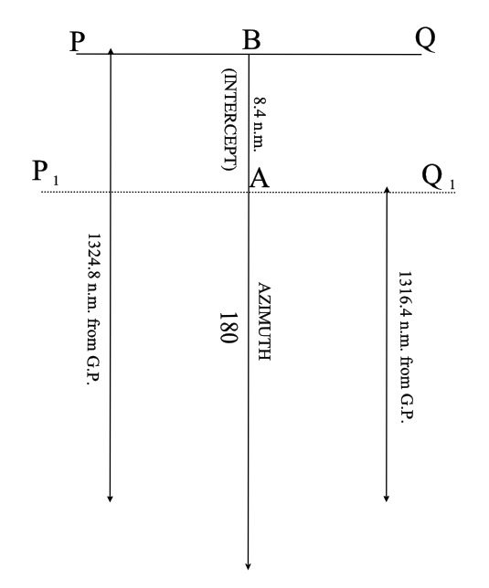
The line PBQ represents part of the circumference of a position circle of radius 1324.8 nautical miles centred at the GP on which the assumed position (B) lies.
The line P1AQ1 represents part of the circumference of a position circle of radius 1316.4 nautical miles centred at the GP on which the true position (A) lies. The line BA represents the intercept which we have calculated to be 8.4 nautical miles in the direction 180o from the assumed position.
Note. Since the circumference of a circle at any point is at right-angles to the radius at that point, no accuracy will be lost by drawing the small arcs PBQ and P1AQ1 as a straight lines at right-angles to the intercept
However, we still have only one position line whereas we need at least two position lines to make a fix on the chart. So how can we use the intercept method to establish a fix?
The answer is quite simple. We can lay off on the chart, the vessel’s course and distance run over the next hour (say 315o , 15 nautical miles) to establish a new assumed position and from the new assumed position we can calculate a new position line. At the same time, we can transfer the first position line over the course and distance travelled by the vessel in that hour. The True Position will be at the point of intersection of the new position line and the transferred position line as shown in the diagram below.

A fuller explanation of this topic is given in the book ‘Astro Navigation Demystified’.
Astro Navigation blog: Astro Navigation Demystified.


You must be logged in to post a comment.