
Several readers have raised questions relating to my post dealing with the Intercept Method. These questions mostly concern the relationship between altitude and zenith distance and also the relationship between angular distance and the nautical mile.
Since several chapters of my book Astro Navigation Demystified are devoted to answering these questions, it is very difficult to cover them in one relatively short post. However, the following attempts to provide the answers in as concise manner as possible.
The Relationship Between Altitude and Zenith Distance. We usually consider azimuth and altitude from a position on the surface of the Earth. To fully understand how these phenomena relate to the LHA and declination of a celestial body and hence, how they help us to establish our position, we need to consider them in relation to the celestial sphere.
Consider the following diagram.
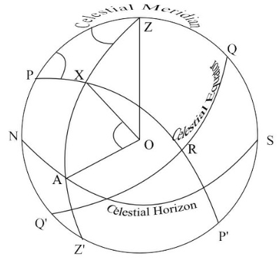
The celestial sphere is drawn in the plane of the observer’s meridian with the observer’s zenith (Z) at the top.
Point O represents both the observer and the Earth.
The arc PZQSP’ represents the observer’s celestial meridian.
The arc NAS is the celestial horizon and QRQ’ represents the celestial equator.
ZXAZ’ is a vertical circle running through the position of the celestial body (X). (A vertical circle is a great circle that passes through the observer’s zenith and is perpendicular to the celestial horizon).
The Altitude is the angle AOX in the diagram; that is the angle from the celestial horizon to the celestial body measured along the vertical circle.
The Zenith Distance is the angular distance ZX measured along the vertical circle from the zenith to the celestial body; that is the angle XOZ.
Since the celestial meridian is a vertical circle and is therefore, perpendicular to the celestial horizon, it follows that angle AOZ is a right angle and angles AOX and XOZ are complementary angles. From this we can deduce that:
Zenith Distance = 90o – Altitude
and Altitude = 90o – Zenith Distance
Therefore, if we calculate the altitude at the assumed position and at the same time, we measure the altitude at the true position, then we can calculate the intercept as follows:
Zenith Distance at true position = 90o – measured altitude
Zenith Distance at assumed position = 90o – calculated altitude
Intercept = Zenith Distance at true position ∆ Zenith Distance at assumed position
Expressing the Angular Distance of the Zenith Distance in terms of Nautical Miles. Refer to the diagram below.

Angle ZPX is the local hour angle and side ZX is the angular distance subtended by angle ZPX. So, if the hour angle is 10o , the angular distance ZX will be 10 x 60 minutes of arc and since 1 minute of arc subtends a distance of 1 nautical mile on the Earth’s surface, ZX will be 600 nautical miles in this case.
A fuller explanation of this topic is given in the book ‘Astro Navigation Demystified’.


60 nautical miles or 600?
Whoops! – typo. Thanks
Hello. I’m wondering if you might help with a project I’m working on. I’m performing a layman’s study on the affect of the Sun and Moon’s gravitational pull on tides and oceanic winds. As a non-scientist I’m afraid that my scientific jargon is quite constricted and hope that you will be able to understand what it is that I desire. Basically I am looking for a way to calculate the Earth’s GPS coordinates that would be considered “high noon” in terms of the suns position to that set of coordinates. It would be that point where the observer in those coordinates would have to look directly above to the center of the sky to see the sun. (or moon.) In an attempt to use your own terms I think it means that GPS spot where the altitude would be directly above at 180 degrees and the azimuth would be 0. I always thought that GPS coordinate was called the “zenith,” but I’m not certain of that.
It would take far too long for me to explain this in this blog but you will find the answers to your questions in my books ‘Astro Navigation Demystified’ and ‘Astronoy For Astro Navigation’ which are available from Amazon.