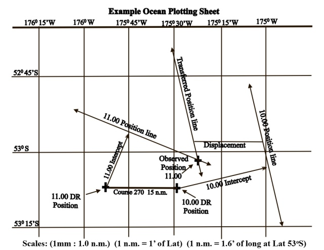
Ocean plotting sheets are nautical charts designed for use at specific latitudes. They are used for ocean navigation where features such as shorelines, water depths and local tidal information are of no importance. Plotting sheets are particularly useful for plotting observed positions obtained by astro navigation.
Purchasing ocean plotting sheets can be an expensive outlay particularly when they are required for navigation courses or for practising plotting skills so why not make your own, all you need is a sheet of graph paper.
A nautical chart is a graphic representation of a sea area and is based on the principle of the Mercator projection which represents curved lines on the Earth’s surface as straight lines on the chart.
Chart-Scale. This is the ratio between distance on the ground and the corresponding distance on the chart. The example below shows part of an ocean plotting sheet. In the example, you will see that three different scales seem to have been used; one for distance, one for longitude and one for latitude. The reasons for this are explained below.
Nautical Mile. The international nautical mile (n.m.) is closely related to the geographical mile and is a unit of length corresponding to approximately 1 minute of arc along any meridian of longitude. It is defined as exactly 1852 metres. .
Longitude. Meridians of longitude are by definition great circles and an angle of 1 minute at the Earth’s centre will subtend an arc of 1 nautical mile along the surface of a great circle. From this it follows that 1 minute of arc along a meridian of longitude is equal to a distance of 1 nautical mile and 1 degree of arc is equal to 60 nautical miles. Since the chart scale in the example below is 1mm: 1 nautical mile and since 1 minute of latitude when measured along a meridian of longitude = 1 n.m. the scale used for latitude is 1 mm : 1′ of lat.
Latitude. A parallel of latitude is a small circle that is parallel to the Equator. We know that the distance between adjacent meridians of longitude when measured along the Equator is 60 n.m. This is because the Equator is a great circle; however, parallels of latitude are small circles and this presents us with a problem. Moving from the Equator towards the poles, the meridians of longitude gradually converge and the circumference of the parallels of latitude gradually become smaller. Because of this, the distance between adjacent meridians of longitude when measured along a parallel of latitude has to be calculated for each parallel.
Calculating the distance between adjacent meridians of longitude along parallel of latitude 53oS in the example below. As explained in my book ‘Applying Mathematics To Astro Navigation’, the formula for calculating the distance along a parallel of latitude is “difference in distance (Ddist) = difference in longitude (Dlong) x Cos(Lat)” Therefore, the distance between adjacent meridians of longitude when measured along parallel of latitude 53oS is calculated as follows: Ddist. = Dlong x Cos(Lat) = 1o x Cos(53) = 60’x Cos(53) = 60 x 0.6 = 36 n.m. Therefore, since the chart-scale is 1mm : 1 n.m., the scale distance between adjacent meridians of longitude along latitude 53oS in the example is 36 mm.
We change the subject of the formula above to calculate the difference in longitude for 1 n.m. measured along lat. 53oS as follows: Dlong = Ddist ÷ Cos(Lat) = 1 ÷ Cos(53) = 1 ÷ 0.6 = 1.66….. So 1 nm = 1.66’….. of long when measured along parallel of latitude 53oS.
Summary. The scales used in the example plotting sheet are: 1mm : 1 n.m. 1 n.m. = 1′ of Lat so 1mm : 1′ of Lat 1 n.m. = 1.66…’ of long along latitude 53oS. 1o Long = 36 n.m. along latitude 53oS
Note. The image of the example plotting sheet below has been reduced to fit the page and so it does not reflect the actual chart-scale.
Books of the Astro Navigation Demystified Series:
Applying Mathematics to Astro Navigation
Astronomy for Astro Navigation
Celestial Navigation. Theory and Practice
email: astrodemystified@outlook.com


You must be logged in to post a comment.