
Link: History of the Mason Dixon line
Jeremiah Dixon and Charles Mason plotted the famous Mason Dixon Line in 1765, long before the days of GPS or any other electronic navigation equipment. How was it then that they were they able to fix positions from the midst of the forests of the Iroquois?
They would not have been able to survey the land using triangulation methods because suitable landmarks would have been hidden by the trees. They would not have been able to measure the altitude of celestial bodies because there would not have been a visible horizon. All they would have been able to see would be a small circle of sky through the canopy above them and therein lies the clue.
They used an instrument known as a zenith sector which is a fixed vertical telescope through which an observer is able to view a small circle of sky centred at the zenith of his geographical position. By using this device, they were able to accurately measure the zenith distance of celestial bodies that came within the telescope’s field of view.
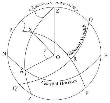
In the diagram below, Z marks the zenith of the observer, X is the position of a celestial body and O is the Earth’s centre. The zenith distance is the angular distance ZX which is subtended by the angle XOZ . In other words it is the angular distance from the observer’s zenith to the celestial body. (For a fuller explanation of zenith distance follow this link:)
By measuring the zenith distance of a celestial body at the instant that it crosses the observer’s meridian, the observer is able to determine the latitude of his position because the zenith distance will be equal to the distance from the latitude of the geographical position of the body to the latitude of the observer in nautical miles measured north or south (click here for an explanation of this).
Mason and Dixon plotted their line in this way choosing stars whose declinations were close to the latitude 39o 43′ N, the east/west boundary between Pennsylvania and Maryland. Because the chronometer had not yet been invented, they were not able to calculate longitude which partly explains why their line ran along a parallel of latitude.
They chose to use only stars for their observations because the declination of a star changes very slowly and can be considered to be fixed for short periods of time. Furthermore, the magnification of the zenith sector telescope is far greater than the telescope of a sextant and so they were able to use many faint stars that we would not normally be able to use for navigation.
To establish a north/south boundary they would have followed a line bearing true south or true north from a known landmark such as a hill or small town. It is interesting to note that the majority of the boundaries between American states, which were established before the advent of the chronometer, also ran east/west or north/south.
The boundary between Delaware and Pennsylvania, which was also fixed by Mason and Dixon, involved mainly conventional surveying techniques because it followed an arc known as the ‘twelve mile circle’ around the town of New Castle. Similarly, the Delaware-Maryland boundary was based on conventional surveying because it was designed to bisect the Delmarva Peninsular instead of following a meridian.
A more detailed treatment of the topic of zenith distance can be found in Astro Navigation Demystified’.
Books of the Astro Navigation Demystified Series:
Applying Mathematics to Astro Navigation
Astronomy for Astro Navigation
Celestial Navigation. The Ultimate Course


You must be logged in to post a comment.