
In my previous post about the meridian passage long method, I demonstrated how the ‘Short Distance Sailing Formulas’ are used to calculate a vessel’s position at meridian passage. I have since received several questions asking how these formulas allow for the varying distances between the meridians of longitude. Therefore, this post is dedicated to the task of explaining how the short distance sailing formulas are derived.
As I have done in all of my books, I will attempt to avoid over-complicated and stilted academic language and as far as possible, give my explanations in straightforward, plain English.
Links: Understanding Meridian Passage, Meridian Passage Short Method, Meridian Passage Long Method What is the point of meridian passage? Zone Time, Local Hour Angle and Greenwich Hour Angle, Converting GMT to GHA , Altitude Corrections
Measuring the Distance Between Meridians of Longitude Along a Parallel of Latitude. In the diagram below, PBC and PAD lie on separate meridians of longitude.
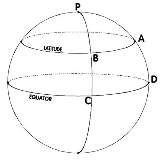
The arc BA is the distance between these meridians measured along a certain line of latitude. The arc CD is the distance between the same meridians measured along the Equator. Clearly, the distance CD is much greater than the distance BA
To Calculate The Distance Between Two Meridians Along A Parallel Of Latitude. The following formulas are used for calculating the difference in distance along a parallel of latitude (Ddist) corresponding to a difference in longitude (Dlong) and vice versa.
Ddist = Dlong x Cos Lat. and Dlong = Ddist ÷ Cos Lat.
Since the secant is the inverse of the cosine, the formula for Dlong can be simplified to: Dlong = Ddist x Sec Lat.
The Rhumb Line. If a ship were to steer a steady course, that is one on which her heading remains constant, her track would cut all meridians at the same angle, as the next diagram shows. Such a line on the Earth’s surface is called a rhumb line.

When the rhumb line cuts all meridians at 90o, it will coincide with either a parallel of latitude or with the Equator. When the angle is 0o, the rhumb line will be along a meridian of longitude.
A vessel’s course will always be a rhumb line; thus the course to be steered to travel from one place to another will refer to the angle between the rhumb line joining the places and any meridian.
Calculating the distance between two points along a rhumb line. In the next diagram, A, B, C, D and Z are meridians of longitude; the lines aB, bC, and cD are different parallels of latitude; and the line ABCDZ is a rhumb line. A series of right-angled triangles have been constructed along the rhumb line AZ and in each triangle, one short side lies along a meridian of longitude, one lies along a parallel of latitude and the hypotenuse lies along the rhumb line.
 It can be seen from the diagram that the east-west distance between two points along the rhumb line is the sum of the distances along the parallels of latitude corresponding to the difference in longitude in each of the right-angled triangles. This east-west distance is known as the departure
Middle Latitude. If we were to calculate the departure along each of the parallels of latitude aB, bC, cD, we would find that they would not be equal and so the task of calculating the total departure would be complicated. In practice, the total departure is taken to be the east-west distance along the intermediate of these parallels which is known as the ‘middle latitude’.
By the formula established for Ddist above, we can derive a formula to calculate departure as follows: Departure = d.long cos(middle latitude).
Mean Latitude. In most cases, the arithmetic mean of the two latitudes can be used as the middle latitude without appreciable error, so the approximate formula dep.= d.long cos(mean lat) may be used.
When the difference of latitude is large (over 600 n.m.) or the latitudes are close to either of the poles, the middle latitude must be used instead of the mean latitude and in these cases, we have the more accurate formula: Dep. = d.long cos(mid lat).
The difficulty lies in the task of calculating the middle latitude which involves finding the mean of the secants all the intermediate latitudes by integration. Such methods are obviously impracticable in situations where courses and distances have to be calculated rapidly at sea. For this reason, tables of corrections to be applied to the mean latitude are contained in various collections of nautical tables. Since, celestial navigation involves short distance sailing calculations, it is not intended to copy middle latitude correction tables here; however, the following example demonstrates their use:
Suppose a ship sails from position 50oN, 32oE., to 70oN., 15oE.
The d.long is 17o and the mean latitude is 60o.
The formula for calculating departure using the mean lat. is: dep.= d.long cos(mean lat)
Using this formula we have:
Dep. = 17o cos(60)
= 1020’ cos(60)
= 510’ or 510 n.m.
In the tables for converting mean latitude to middle latitude, the correction for a mean latitude of 60o and a difference of latitude of 20o is +1o 09’. So the middle latitude = 61o.15.
The formula for calculating departure using the middle latitude is: Dep. = d.long cos(mid lat) = 1020 cos (61.15) = 492.17 n.m.
By comparing these results, we can see that there is a significant difference between calculations involving the mean latitude on one hand and the middle latitude on the other.
Summary of Formulas. The formulas so far derived in this appendix are summarized below:
Ddist = Dlong x Cos Lat.
Dlong = Ddist ÷ Cos Lat = Ddist x Sec Lat. .
dep.= d.long cos(mean lat) (for distances 600 n.m. or less).
Dep. = d.long cos(mid lat). (for distances over 600 n.m.).
The Rhumb Line Formulas. With the next diagram, we expand on the work above:

- The rhumb line AZ is divided into a large number of equal parts AB, BC, CD, DZ.
- aB, bC, cD… are arcs of parallels of latitude drawn through B, C, D…..
- Pa’, Pb’, Pc’… are meridians of longitude.
- Therefore, the angles at a, b, c….. are right angles.
- If the divisions of AZ are made sufficiently small, the triangles ABa, BCb, CDc….. will be small enough to be treated as plane triangles instead of spherical triangles.
- Since the course angle is constant by the definition of a rhumb line, these small triangles are equal.
Consider triangle ABa in the diagram above: AB is the distance made good, aB is the departure along a parallel of latitude, angle aAB is the course angle.
Therefore, Sin(course angle) = departure ÷ dist. This formula applies to all of the small triangles since they are equal.
By transposition, the above formula becomes: Dep = Dist x sin(course)
The departure between A and Z therefore, is the sum of the departures of all of the small triangles. Therefore, by addition:
aB + bC + cD + …. = (AB + BC + CD + …. x sin(course)
i.e. Dep = Dist sin(course)
If we again consider triangle ABa, Aa = AB cos (course)
But Aa is the difference in Latitude (D.Lat) between A and B
So D.Lat = AB cos(course)
Again, this formula applies to all of the small triangles since they are equal. Therefore, by addition, the total D.Lat corresponding to the total distance between A and Z becomes:
D.Lat = Dist cos(course)
We have established formulas to calculate Dep and D.Lat; we now need a formula to find the course.
If we return to triangle ABa, we can see that the course angle can be found by the formula: tan(course) = Dep ÷ D.Lat.
As before, this formula applies to all of the small equal triangles. So, by addition, the rhumb line course between A and Z can be found by the formula:
Tan(course) = Dep ÷ D.Lat
Short Distance Sailing. Short distance sailing is a term which is applied to sailing along a rhumb-line for distances less than 600 nautical miles. From the formulas derived above, the following are used extensively in short distance sailing:
To Calculate Departure when the course is not known: dep.= d.long cos(mean lat)
To Calculate Departure when the course is Known: Dep = Dist x Sin(course)
To Calculate Distance when departure and course are known:
Dist = Dep ÷ Sin (course)
To Calculate Dlat when the distance and course are known:
DLat = Dist x Cos(course)
To Calculate Course to Steer (the rhumb line course between two points)
Tan(course) = Dep ÷ D.Lat
To calculate Dlong (difference in longitude corresponding to the departure):
DLong. = Dep. x Sec(Mean.Lat) or Dlong = Dep ÷ Cos(Mean.Lat)
Worked Example. What is the rhumb line course to steer and the distance to travel from position 40o.5N, 43o.0W to position 42o.25N 41o.8W?
Solution:
| Dlat = 42o.25N – 40o.5N = 1o.75N = 105’N
Mean Lat = 40o 30’N + 52’.5 = 41o 22’.5N Dlong = 43o.0W – 41o.8W = 1o.2E = 72’E Dep = d.long x cos(mean lat) = 72 cos(41.38) = 54’.02 Tan(course) = Dep ÷ D.Lat = 54.02 ÷ 105 = 0.51 Therefore course = N27oE = 027o Dist = Dep ÷ Sin (course) = 54.02 ÷ Sin(27) = 120’ Course to steer = 027o Distance to new position = 120 n.m. |
Where to buy books of the Astro Navigation Demystified series:
Celestial Navigation at Amazon.com
Celestial Navigation at Amazon.uk
Astro Navigation Demystified at Amazon.com
Astro Navigation Demystified at Amazon.uk
Applying Mathematics to Astro Navigation at Amazon .com
Applying Mathematics to Astro Navigation at Amazon .uk
Astronomy for Astro Navigation at Amazon.com
Astronomy for Astro Navigation at Amazon.uk
web: http://www.astronavigationdemystified.com
e: astrodemystified@outlook.com


You must be logged in to post a comment.