The Demystified Astro Navigation Course Unit 2

Unit 2 – Local Hour Angle and Greenwich Hour Angle

 Local Hour Angle (LHA).  In astro navigation, we need to know the position of a celestial body relative to our own position.

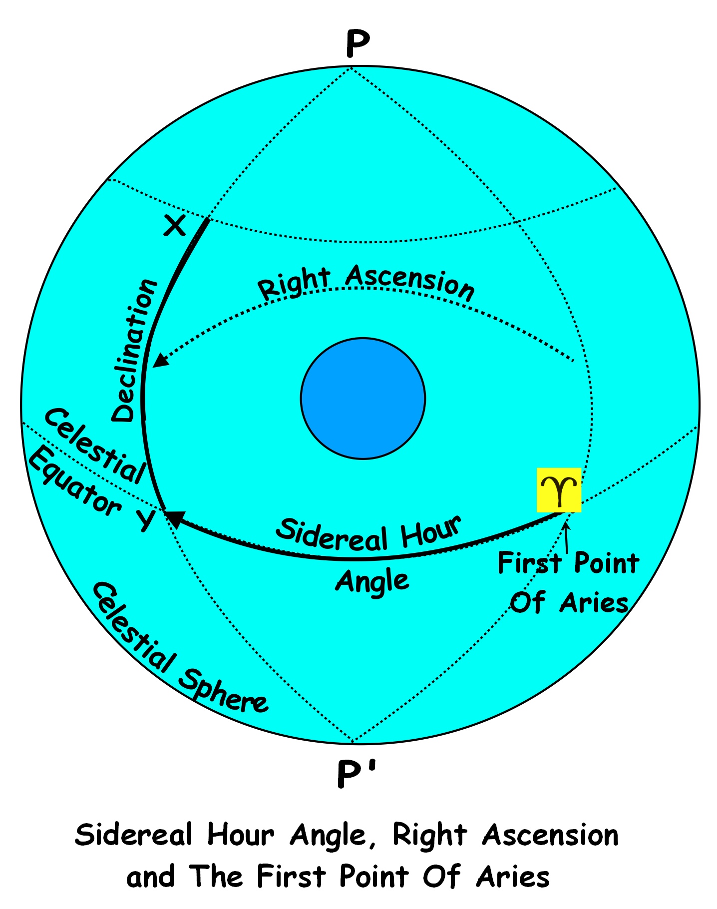
(The following diagram illustrates the explanations given below).

PZX TRIANGLE

LHA is the angle ANU on the Earth’s surface which corresponds to the angle ZPX in the Celestial sphere.   In other words, it is the angle

between the meridian of the observer and the meridian of the geographical position of the celestial body.

Due to the Earth’s rotation, the Sun moves through 15o of longitude in 1 hour and it moves through 15 minutes of arc in 1 minute of mean time.  So the angle ZPX can be measured in terms of time and for this reason, it is known as the Local Hour Angle.

Greenwich Hour Angle (GHA).  The hour angle between the Greenwich Meridian and the meridian of a celestial body is known as the Greenwich Hour Angle.

The Local Hour Angle between an observer’s position and the geographical position of a celestial body can be found by combining the observer’s longitude with the GHA. This is demonstrated in the following diagram.

GHA and LHA

O represents the longitude of an observer;

X represents the meridian of a celestial body;

G represents the Greenwich Meridian.

Because, in this case, the observer’s longitude is east and because LHA is measured westwards from the observer’s meridian to the meridian of the celestial body, LHA is equal to the GHA plus the longitude.

So we have the rule:  Long East, LHA = GHA + LONG

Note.  If the result is greater than 360o, we must modify the rule so that the result will be between 0o and 360o.  So the rule now becomes:

Long East, LHA = GHA + LONG (-360o as necessary).

For example: If Long. is 90oE. and GHA is 300o

Then LHA = GHA + LONG -360o

= 300o + 90o = 390o – 360o = 30o

If the longitude is to be west then the rule will change so that LHA would equal GHA minus Longitude. In this case, the rule is:

Long West, LHA = GHA – LONG

Note.  If the result is greater less than 360o, we must modify the rule so that the result will be between 0o and 360o.  So the rule now becomes:

Long West, LHA = GHA – LONG (+ 360o as necessary)

For example, if Long. is 90oW. and GHA is 45,o we have:

LHA = 45o – 90o = -45o + 360o = 315o

Calculating the Greenwich Hour Angle. The Nautical Almanac contains tables of raw data concerning the Greenwich Hour Angle for the Sun, the Moon, the navigational planets and selected stars.

The extract shown below, is of the Nautical Almanac daily page displaying hourly values of the Greenwich Hour Angle and the Declination of the Sun and the Moon for the 24th.  December.  The examples following demonstrate how the daily pages are used to calculate GHA:

na_2009-249 copycropped2
Example 1.  To find the LHA and Declination of the Sun.  
At 04 hours, 32 minutes, 04 seconds GMT on 24 December 2009, the assumed position of your yacht is 40o 35.5’ South 32o 13.8’ East.   Find the LHA and Declination of the Sun.

 Calculating the Local Hour Angle (LHA).  Before we can calculate the LHA, we need to find the Greenwich Hour Angle of the Sun.  

 Step 1.  Find the GHA for 0400 GMT.   From the daily page extract, we find that the GHA of the Sun for 24 December at 0400 is 240o 07’.5.  This is written as:  GHA (04h) : 240o 07’.5

Step 2.  Calculate the increment for 32 minutes, 04 seconds:  In this step, we find the increase in GHA for minutes and seconds of GMT.

The Nautical Almanac contains tables of corrections for increments of time from 0 minutes to 59 minutes.  The following extract shows the increments and corrections tables for 32 minutes.

32 33cropped2

From the extract we see that, in the table for 32m, the increment for 04 seconds is 8o 01’.0

This is written as:

Inc. (32m 04s):  8o 01’.0

Note.  Since GHA is always increasing, the increment correction is always added.

 Step 3.  Calculate GHA at 04 hr 32 min 04 sec GMT

GHA (04h)             240o 07’.5

Inc. (32m 04s)         + 8o 01’.0

GHA Sun               248o 08’.5

 Step 4.  Find LHA 

In this step, we combine the GHA with the longitude to calculate the LHA:

GHA                       248o 08’.5

Long:                     +  32o 13’.8 East

LHA Sun                 280o 22’.3

The full procedure for calculating the LHA of the Sun can be summarised in the following format:

GHA Sun (04h)       240o 07’.5

Inc. (32m 04s)            8o 01’.0

GHA Sun               248o 08’.5

Long                        32o 13’.8 E.  (+)

LHA Sun                280o 22’.3

Click here for an exercise in this topic

 (Note. This topic is covered in greater depth in the book ‘Astro Navigation Demystified’).

Note.  Units of this course are issued weekly.

Watch for unit 3

Where to buy books of the Astro Navigation Demystified series:

Astro Navigation Demystified at Amazon.com

Astro Navigation Demystified at Amazon.uk

Applying Mathematics to Astro Navigation at Amazon .com

Applying Mathematics to Astro Navigation at Amazon .uk

Astronomy for Astro Navigation at Amazon.com

Astronomy for Astro Navigation at Amazon.uk

web: http://www.astronavigationdemystified.com

e: astrodemystified@outlook.com

Posted in astro navigation, astronomy, celestial navigation | Tagged , , , , | Leave a comment

The Demystified Astro Navigation Course – Unit 1

Unit 1 Essential Astronomy for Navigators

EARTH AND SUN IN THE SPHERE

The Celestial Sphere is an imaginary sphere with the Earth located at its centre. We imagine that the ‘celestial bodies’ such as the Sun, Moon, stars and planets are placed on the inner surface of the celestial sphere just as we would see them in the sky.

Ecliptic.  Although it is the Earth that orbits the Sun, it appears to us that the Sun moves around the celestial sphere taking one year to complete a revolution. This apparent movement of the Sun is called the Ecliptic.

Earth’s Rotation.  It takes exactly 24 hours for the Earth to turn once on its axis with respect to the Sun but it takes 23 hours, 56 minutes and 4 seconds to complete one rotation with respect to the rest of the universe.  The amount of time it takes for the Earth to turn on its axis with respect to the universe is know as the sidereal day and the time taken with respect to the Sun is called a solar day.

Ecliptic Poles.  If we imagine a line taken from the centre of the Earth to the Sun, it will be at right angles to the path of the ecliptic and where this line meets the celestial sphere will mark the north and south ecliptic poles.

Celestial Poles.  These are the points where the Earth’s axis of rotation meets the celestial sphere.

Geographic Poles.  These are the points where the Earth’s axis of rotation meets the Earth’s  surface.  These are simply known as the North Pole and the South Pole.

True North.  The direction from a position on the Earth’s surface towards the Geographic North Pole is known as True North.

 Magnetic Poles.  These are the north and south poles of the Earth’s magnetic field and are offset slightly from the geographical poles.

Magnetic North.  The direction from a position on the Earth’s surface towards the Magnetic North Pole is known as Magnetic North.

Deviation.  The difference between magnetic north and true north is known as deviation.

Axial Tilt.  The Earth’s axis is not in line with the Ecliptic Poles but is offset at an angle of 23.4°.  In other words, axial tilt is the angle between the geographic/true north pole and the ecliptic north pole measured from the Earth’s centre.

The Earth’s Equator is an imaginary line on the Earth’s surface the plane of which is at right angles to the axis of rotation.  It is equidistant from the North and South Poles and divides the Earth into the Northern Hemisphere and Southern Hemisphere.

The Celestial Equator is the projection of the Earth’s equator onto the surface of the celestial sphere.

DeclinationThe declination of a celestial body is its angular distance North or South of the Celestial Equator.

The tropic of Cancer.  This is where the Sun’s declination reaches its northernmost latitude of 23.4oN.

The tropic of Capricorn.  This is where the Sun’s declination reaches its southernmost latitude of 23.4oS.

The Equinoxes.  The Sun crosses the celestial equator on two occasions during the course of a year and these occasions are known as the equinoxes.  Because the Sun is on the celestial equator at the equinoxes, its declination is of course 0o.

The Autumnal Equinox occurs on about the 22nd. September when the Sun crosses the celestial equator as it moves southwards.

The Vernal Equinox occurs on about the 20th.March when the Sun crosses the celestial equator as it moves northwards.

The Solstices.  The times when the Sun reaches the northerly and southerly limits of its path along the ecliptic are known as the solstices.  The Summer Solstice (mid-summer in the northern hemisphere) occurs on about 21st. June when the Sun’s declination reaches 23.4o North (the tropic of Cancer).

The Winter Solstice (mid-winter in the northern hemisphere) occurs on about 21st. December when the Sun’s declination is 23.4South (the tropic of Capricorn).

First Point of AriesIn astronomy, we need a celestial coordinate system for fixing the positions of all celestial bodies in the celestial sphere.  To this end, we express a celestial body’s position in the celestial sphere in relation to its angular distances from the Celestial Equator and the celestial meridian that passes through the ‘First Point of Aries.   This is similar to the way in which we use latitude and longitude to identify a position on the Earth’s surface in relation to its angular distances from the Equator and the Greenwich Meridian. The First Point of Aries is usually represented by the ‘ram’s horn’ symbol shown below:

aries-znak

Just as the Greenwich meridian has been arbitrarily chosen as the zero point for measuring longitude on the surface of the Earth, the first point of Aries has been chosen as the zero point in the celestial sphere.  It is the point at which the Sun crosses the celestial equator moving from south to north along the ecliptic (at the vernal Equinox in other words).

Right Ascension (RA).   This is used by astronomers to define the position of a celestial body and is defined as the angle between the meridian of the First Point of Aries and the meridian of the celestial body measured in an Easterly direction from Aries.

Sidereal Hour Angle (SHA). This is similar to RA in as much that it is defined as the angle between the meridian of the First Point of Aries and the meridian of the celestial body.  However, the difference is that SHA is measured westwards from Aries while RA is measured eastwards.

These concepts are illustrated by the diagram below:

 RA SHA ARIES

X is the position of a celestial body in the celestial sphere.

PXP’ is the meridian of the celestial body.

Y is the point at which the body’s meridian crosses the celestial equator.

Note.  Units of this course will be issued weekly.

Watch for unit 2

A thorough treatment of this topic can be found in the book Astro Navigation Demystified.

Where to buy books of the Astro Navigation Demystified series:

Astro Navigation Demystified at Amazon.com

Astro Navigation Demystified at Amazon.uk

Applying Mathematics to Astro Navigation at Amazon .com

Applying Mathematics to Astro Navigation at Amazon .uk

Astronomy for Astro Navigation at Amazon.com

Astronomy for Astro Navigation at Amazon.uk

web: http://www.astronavigationdemystified.com

e: astrodemystified@outlook.com

Posted in astro navigation, astronomy, celestial navigation, celestial sphere, navigation | Tagged , , , , | Leave a comment

Calculating the Distance Between Meridians of Longitude Along a Parallel of Latitude.

At the Equator, the distance between meridians of longitude is 60 n.m. (or 60.113 to be precise).  However, as we move north or south away from the equator, we find that the distance between them decreases as they converge towards the poles.  So how do we calculate the distance between meridians of longitude along a particular parallel of latitude?

Consider the diagram below.Drawing21Let CD be an arc of no of longitude measured along the circumference of the great circle which is the Equator.

Let AB be an arc of no of longitude measured along a parallel of latitude.

Let Q be the centre of the plane of the small circle which is the parallel of latitude.

Let O be the centre of the plane of the Equator.

Then angle A Q B  =  angle D O C

Using the formula C = 2πr, we can deduce that the circumference of the Equator equals 2π.CO (since CO represents the radius of the Earth in the diagram).

Therefore it follows that 1o of longitude corresponds to an arc of

2π.CO / 360

⇒  CD = 2πn.CO /360     ⇒  CO = 360.CD  / 2πn

by similar argument:

AB = 2πn.BQ / 360     ⇒  BQ = 360.AB / 2πn

angle BOC  represents the latitude,

Therefore angle QOB = 90o – Lat.

and angle QBO = Lat. (alternate angles).

angle OQB =  90o (since the plane of QAB is at right-angles to the polar axis).

⇒ QBO is a right angle triangle

Therefore Sin (QOB) = BQ/BO

⇒ Sin (90o – Lat.)  =  BQ / BO

Also    CO = BO  =  r (since r = Earth’s radius)          ⇒Sin (90o-Lat.) = BQ /CO

(since angle QBO = Lat.)

Also Cos  Lat.    =   BQ/CO   (since CO = BO)

⇒ BQ  =  CO Cos Lat.

⇒  360.AB /2πn   =  360.CD Cos Lat /2πn

⇒ arc AB = arc CD Cos Lat.

⇒ Distance AB =  CD (difference in long) x Cos Lat. (since 1 nautical mile along the Equator equals 1 minute of arc).

Therefore, to calculate the difference in distance along a parallel of latitude (Ddist) corresponding to a difference in longitude (Dlong) we have the formula:

Ddist = Dlong x Cos Lat.

⇒ Dlong  =  Ddist /Cos Lat.

Note.  Since the secant is the inverse of the cosine, the formula for Dlong can be simplified to:     Dlong = Ddist x Sec Lat.

Click here for a practice exercise on this topic.

A thorough treatment of this topic can be found in the book Astro Navigation Demystified.

Posted in astro navigation, Astro Navigation Topics, celestial navigation, navigation | Tagged , , | Leave a comment

Altitude Correction for Parallax

As shown in the following diagram, the observer measures the altitude in relation to the visible horizon from his position at O on the Earth’s surface.  So, the observed altitude is the angle HOX.  However, the true altitude is measured from the Earth’s centre in relation to the celestial horizon and is the angle RCX.

parallax

Point O will be approximately 6367 Km. from the centre of the Earth and so it would seem that the visible horizon is bound to be slightly offset from the celestial horizon.  Because of the vast distances of the stars and the planets from the Earth, we can assume that, in their cases, the celestial horizon and the visible horizon correspond with very little error.  However, in the cases of the Sun and the Moon, which are relatively near, a correction called Parallax must be added.

 Parallax. We measure the altitude of a celestial body from our position in relation to our visible horizon; this is known as the observed altitude.  However, when calculating the true altitude, measurements are made from the Earth’s centre in relation to the celestial horizon.  The displacement between the observed position of an object and the true position is known as parallax.

Parallax corrections for stars and planets.   Because the stars and the planets are at such great distances from the Earth, we can assume that, in their cases, the celestial horizon and the visible horizon correspond with very little error. However, in certain cases when extreme accuracy is needed, parallax corrections for Mars and Venus are required and these are listed in the altitude correction tables.

Parallax corrections for the Sun and the Moon.  Because the Sun and the Moon are relatively close to the Earth, parallax will be significant and so a correction has to be made.  These corrections are included in the altitude correction tables and therefore do not have to be applied separately.

Horizontal Parallax. Parallax error is greatest when the celestial body is close to the horizon and decreases to zero as the altitude approaches 90o.  It is negligible except in the case of the Moon which is close to the Earth in comparison with the other celestial bodies.  Because horizontal parallax is significant in the case of the Moon, a separate correction (abbreviated to HP) has to be applied.

Links:  Altitude Correction for Dip       Altitude Correction For Semi-Diameter

(A thorough treatment of this topic can be found in the book Astro Navigation Demystified).

Contact us: astrodemystified@outlook.com

Posted in astro navigation, Astro Navigation Topics, astronomy, celestial navigation | Tagged , , | Leave a comment

Altitude Correction for Dip

Dip.  A correction has to be made to the sextant altitude to allow for the height of the observer’s eye above the horizon; this is known as Dip.

Consider the diagram below:

O is an observer’s position on the Earth’s surface and E is the position of his eye.  We can see that, as the observer’s height of eye is raised above sea level, his visible horizon ‘dips’ below the true horizon and so the altitude measured at E becomes greater than that measured at O.

nonum diag26

Dip is the error caused by this difference and has to be subtracted from the reading.

Effect of Refraction on Dip.  As well as increasing the apparent altitude of a celestial body, refraction also has an effect on the position of the visible horizon and this will in turn, have an effect on the angle of dip.

The effects of refraction are illustrated in the next diagram.

diag 27

XEH is the true altitude from the observer’s height of eye.  However, due to refraction, the celestial body appears to be at Y and so YEH becomes the apparent altitude.

ET is a tangent from the observer’s eye to the Earth’s surface and so T1 should  mark the position of the horizon from E.

The theoretical angle of Dip is the angle HET; however, because refraction causes the horizon to appear to be in the direction of R, angle HER becomes the angle of dip.

(A thorough treatment of this topic can be found in the book Astro Navigation Demystified).

Posted in astro navigation, Astro Navigation Topics, celestial navigation, navigation | Tagged , , | Leave a comment

Altitude Correction for Semi-Diameter

An adjustment for semi-diameter is one of the corrections that may have to be made to the sextant altitude in order to calculate the True Altitude

Corrections For The Moon’s Semi-Diameter.  The point on the Moon’s circumference nearest to the horizon is called the lower limb and the point furthest from the horizon is called the upper limb.  When the Moon is not full, sometimes only the upper limb will be visible and sometimes only the lower limb.

From the diagram below it can be seen that sometimes, depending on the phase of the Moon, either the upper or the lower limb cannot be seen.

image057

It should be noted that whether the Moon’s upper or lower limb is visible is dependent not only on its phase but also on the relative altitudes of the Sun and the Moon.  For example, if one morning, a crescent or gibbous moon is visible in the eastern sky and the Sun is at a higher altitude, only the upper limb will be visible but if, in the evening of the same day, the Moon is visible in the western sky and the Sun has set below the western horizon, only the lower limb will be visible.  In navigational practice, the altitude that we measure is that of the lower limb; however, when the lower limb cannot be seen, we have no choice other than to measure the altitude of the upper limb.

Regardless of which limb we use, what we really need is the altitude of the Moon’s centre so we must either add or subtract the value of its semi-diameter.

The following diagram shows why the semi-diameter must be added when the altitude when the lower limb is measured.


lower limb

As the Moon travels around its orbit and its distance from the Earth changes, so the value of the visible moon’s semi-diameter will change.  The value of the Moon’s semi-diameter for each day is given in the daily pages of the Nautical Almanac.

The semi-diameter of the Sun is also given in the daily pages of the Nautical Almanac.  However, the correction for the Sun’s semi-diameter is included in the Altitude Correction Tables and so need not be separately considered.

Semi-Diameter of Stars and Planets.  To the naked eye and even through a sextant telescope, the stars and planets appear as points of light and so there is obviously no need to apply semi-diameter corrections in their cases.

(A thorough treatment of this topic can be found in the book Astro Navigation Demystified).

Where to buy books of the Astro Navigation Demystified series:

Astro Navigation Demystified at Amazon.com

Astro Navigation Demystified at Amazon.uk

Applying Mathematics to Astro Navigation at Amazon .com

Applying Mathematics to Astro Navigation at Amazon .uk

Astronomy for Astro Navigation at Amazon.com

Astronomy for Astro Navigation at Amazon.uk

Posted in astro navigation, Astro Navigation Topics, astronomy, celestial navigation | Tagged , , | Leave a comment

Converting GMT To GHA

Greenwich Mean Time (GMT) is the local mean time anywhere on the meridian of Greenwich.  In other words it is the Local Hour Angle of the Mean Sun on the meridian of Greenwich.

Since the Greenwich meridian is used as the base meridian from which the longitude of all places on Earth are identified, it provides the link between the LMT of a place and the LMT at Greenwich (or GMT).

Example.  In the diagram below, imagine that we are looking down on the North Pole.

GMT white

P   represents the North Pole

G   represents the position of Greenwich on the Earth’s surface.

GP represents part of the Greenwich Meridian (0o).

MP represents part of the meridian of longitude 45oW and M is a point on that meridian.

AP represents part of the meridian of longitude 30o E and A is a point on that

meridian.

The meridian of the Mean Sun, for a very brief instant, coincides with the meridian 45oW. and so, at that instant, the Local Mean Time at point M is noon.

At the same instant, the Local Hour Angle of the Mean Sun at Greenwich is 45o.   Therefore, the LMT at Greenwich must be 3p.m. since the time difference for 45o is 3 hours and Greenwich is to the East of M.

It follows that the Greenwich Mean Time must also be 3p.m. (since GMT is equal to the LMT at Greenwich).

The LMT at point A must be 2 hours after GMT (since the time difference for 30o is 2 hours and A is to the East of Greenwich).

Therefore, the LMT at point A must be 5p.m.

Greenwich Hour Angle (GHA).  The angle between two meridians of Longitude can be expressed as an hour angle.  The hour angle between the Greenwich Meridian and the meridian of a celestial body is known as the Greenwich Hour Angle.

The Local Hour Angle between an observer’s position and the geographical position of a celestial body can be found by combining the observer’s longitude with the GHA.

In the diagram below , O represents the longitude of an observer;

X represents the meridian of a celestial body;

G represents the Greenwich Meridian.

diag 5 nonumBecause in this case, the observer’s longitude is east and because LHA is measured westwards from the observer’s meridian to the meridian of the celestial body, LHA is equal to the longitude plus the GHA.

For a fuller explanation of GHA and LHA click here

Converting GMT to GHA.

Because GMT is measured westwards from the reciprocal of Greenwich (i.e. 180o) and GHA is measured westwards from the Greenwich meridian (i.e. 0o) we convert GMT to GHA as follows:  If GMT, when converted to arc, is less than 180o then add 180o; if GMT is greater than 180o then subtract 180o).    Examples:

Example 1.  Convert 0840 GMT to GHA.

Step 1.  Convert GMT to arc.

8h   =  8 x 15      = 120o 0’ 0”

40m = 40 ÷ 4    =   10o 0’ 0”

                          =  130o 0’ 0”

Step 2.  Convert to GHA.

GHA  =        130o 0’ 0” + 180o 0’ 0”  = 310o 0’ 0”

Example 2.  Convert 1530 GMT to GHA.

Step 1.  Convert GMT to arc.

15h   =  15 x 15      = 225 0’ 0”

30 =  30 ÷ 4      =     7o 30’ 0”

= 232o  30’ 0”

Step 2.  Convert to GHA.

GHA  =  232o 30’ 0” – 180o 0’ 0”  =  52o 30’ 0”

Note.  Because GHA relates to apparent solar time and GMT relates to mean solar time, we must take the equation of time (EOT) into account when converting GMT to GHA.  Therefore the next example includes a calculation for EOT.

Example 3.  Convert 0415 GMT to GHA.  E0T = +1 m

Equation of Time = mean solar time – apparent solar time

∴ apparent solar time = mean solar time – equation of time

∴ GHA = GMT – EOT.

Step 1.  Convert 0415 GMT to arc.

4h   =  4 x 15      = 60o   0’ 0”

15 =  15 ÷ 4   =   3o 45’ 0”

                           = 63o 45’ 0”

– EOT                            – 1’ 0”   (correction for EOT)

                          = 63o 44’ 0”

Step 2.  Convert to GHA.

GHA =   63o 44’ 0” + 180o 0’ 0’’ =  243o 44’ 0”

A fuller treatment of this topic can be found in the book Astro Navigation Demystified

Posted in astro navigation, Astro Navigation Topics, celestial navigation | Tagged , , , , | Leave a comment

The Role Of Altitude, Azimuth And Zenith Distance In Astro Navigation.

altitude and zenith distance

Point Z represents the zenith of the observer’s position. 

Point X represents the position of the celestial body and this point, if projected onto the Earth’s surface, would correspond to the Geographical position of the body.

P and P1 are the north and south poles respectively.

 The Zenith Distance. The zenith distance is the angular distance ZX that is subtended by the angle XOZ and is measured along the vertical circle that passes through the celestial body.

Relationship Between Zenith Distance And The Nautical Mile.  An angle of 1 minute at the earth’s centre will subtend an arc of length 1 n.m on the earth’s surface.  Therefore if the angle XOZ is 30o (the arc ZX) will be equal to 30 x 60 = 1800 arc minutes at the earth’s surface and so the zenith distance will be equal to 1800 nautical miles.

 The Altitude.  Altitude is the angle AOX, that is the angle from the celestial horizon to the celestial body and is measured along the same vertical circle as the zenith distance.

Relationship between Altitude and Zenith Distance Since the celestial meridian is another vertical circle and is therefore, also perpendicular to the celestial horizon, it follows that angle AOZ is a right angle and angles AOX and XOZ are complementary angles.  From this we can deduce that:

Zenith Distance = 90o – Altitude

and Altitude = 90o – Zenith Distance

Azimuth.  The angle PZX is the azimuth of the celestial body and is the angular distance between the observer’s celestial meridian and the direction of the position of the body.

 The Role Of Altitude, Azimuth And Zenith Distance In Astro Navigation.  It can be seen that by measuring the altitude of a celestial body, we are able to easily calculate the zenith distance which will give us the distance in nautical miles from the observer’s position to the geographical position of the body.  The azimuth will give us the direction of the GP from the observer’s position.  This explains why measuring the altitude and azimuth are the first steps in determining our position in astro navigation.

(A thorough treatment of this topic can be found in the book Astro Navigation Demystified).

Where to buy books of the Astro Navigation Demystified series:

Astro Navigation Demystified at Amazon.com

Astro Navigation Demystified at Amazon.uk

Applying Mathematics to Astro Navigation at Amazon .com

Applying Mathematics to Astro Navigation at Amazon .uk

Astronomy for Astro Navigation at Amazon.com

Astronomy for Astro Navigation at Amazon.uk

Posted in Uncategorized | Leave a comment

The Ecliptic, The Age of Aquarius and the Tropics.

EARTH AND SUN IN THE SPHERE update

The Ecliptic.  Because of the orbital motion of the Earth, the Sun appears to us to move around the celestial sphere taking one year to complete a revolution. This apparent movement of the Sun is called the Ecliptic.  A year is approximately 365.25 days in length.  However; for the sake of convenience, the Gregorian calendar divides three years of the cycle into 365 days and the fourth (the leap year) into 366.

The Age Of Aquarius.  In a popular song, the words the ‘dawning of the age of Aquarius’ refer to the period when the vernal equinox will lie inside the constellation Aquarius.  The vernal equinox is the point where the Sun crosses the Equator on its northward movement along the ecliptic and heralds the first day of spring in the northern hemisphere on 20th./21st.March.  This point is known as the ‘First Point of Aries’ because in 150 B.C. when Ptolemy first mapped the constellations, Aries lay in that position. However, although still named the ‘first point of Aries’, due to precession, the vernal equinox now lies in the constellation Pisces, so logically, it should be named the ‘first point of Pisces’ since we are now in the ‘Age of Pisces’.  There are various predictions of when the next ‘age of Aquarius’ will begin but the most prominent of these is about 2600 A.D.

The Tropic of Cancer. These days, the Sun passes through the constellation Cancer in late July; however, in the time of Ptolemy, this occurred during the summer solstice when the Sun reached 23.4o N, the northern limit of the ecliptic.  The latitude 23.4oN is still called the tropic of Cancer even though the Sun now resides in Taurus at the summer solstice.

The tropic of Capricorn.  In a similar way,  the Tropic of Capricorn is so named because the Sun once passed through the constellation Capricornus during the winter solstice on 21/22 December when the Sun’s declination reached its southernmost latitude of 23.4oS.  However, due to precession, the Sun is now over the constellation Sagittarius at the Winter Solstice.

Note.  The latitude of the tropic of Cancer is currently drifting south at approximately 0.5 arc seconds per year while the latitude of the tropic of Capricorn is drifting north at the same rate.

First Point of Aries

HOME

Where to buy books of the Astro Navigation Demystified series:

Astro Navigation Demystified at Amazon.com

Astro Navigation Demystified at Amazon.uk

Applying Mathematics to Astro Navigation at Amazon .com

Applying Mathematics to Astro Navigation at Amazon .uk

Astronomy for Astro Navigation at Amazon.com

Astronomy for Astro Navigation at Amazon.uk

Posted in astro navigation, astronomy, celestial navigation | Leave a comment

First Point of Aries.

First Point of AriesIn astronomy, we need a celestial coordinate system for fixing the positions of all celestial bodies in the celestial sphere.  To this end, we express a celestial body’s position in the celestial sphere in relation to its angular distances from the Celestial Equator and the celestial meridian that passes through the ‘First Point of Aries.   This is similar to the way in which we use latitude and longitude to identify a position on the Earth’s surface in relation to its angular distances from the Equator and the Greenwich Meridian.

The First Point of Aries is usually represented by the ‘ram’s horn’ symbol shown below:

firstpointofaries

Just as the Greenwich meridian has been arbitrarily chosen as the zero point for measuring longitude on the surface of the Earth, the first point of Aries has been chosen as the zero point in the celestial sphere.  It is the point at which the Sun crosses the celestial equator moving from south to north along the ecliptic (at the vernal Equinox in other words).  This point is known as the ‘First Point of Aries’ because in 150 B.C. when Ptolemy first mapped the constellations, Aries lay in that position. However, although still named the ‘first point of Aries’, due to precession, the vernal equinox now lays in the constellation Pisces.

Right Ascension (RA).   This is used by astronomers to define the position of a celestial body and is defined as the angle between the meridian of the First Point of Aries and the meridian of the celestial body measured in an Easterly direction from Aries.  RA is not used in astro navigation; Sidereal Hour Angle is used instead:

 Sidereal Hour Angle (SHA). This is similar to RA in as much that it is defined as the angle between the meridian of the First Point of Aries and the meridian of the celestial body.  However, the difference is that SHA is measured westwards from Aries while RA is measured eastwards.

The following diagram illustrates the concepts discussed above.

 RA SHA ARIES

X is the position of a celestial body in the celestial sphere.

PXP’ is the meridian of the celestial body.

Y is the point at which the body’s meridian crosses the celestial equator.

aries is the First Point of Aries.

The Sidereal Hour Angle is the angleariesPY.  That is the angle between the meridian running through the First Point of Aries and the meridian running through the celestial body measured at the pole P.  It can also be defined as the angular distanceariesY.  That is the angular distance measured westwards along the Celestial Equator from the meridian of the First Point of Aries to the meridian of the celestial body.

Right Ascension can also be defined as the angle ariesPY  or the angular distanceariesY but the difference is that it is measured in an easterly direction from Aries

From this, we can conclude that

RA    =  360o – SHA and

SHA  = 360o – RA.

A more detailed treatment of this topic is given in the following companion books:

Astronomy for Astro Navigation

Astro Navigation Demystified.

Posted in Uncategorized | Leave a comment